INLAND NW ROUTES |
|
|
iNaturalist Have you ever seen a wildflower on a hike that you didn’t know what it was? THERE’S AN APP FOR THAT. iNaturalist is a free app that will identify any living plant, animal, etc. While you hike, and see a flower or whatever, all you do is take several images, log onto the app and download your image(s). In a few days, they will have their world wide identifiers, tell you what it is. Then they plot where it was photographed. All this data is plotted on a world map, that shows everywhere in the world they grows. After creating an account, all of your observations are in your account, and can be accessed for your future reference. To date, they have over 151,000,000 observations, of 431,785 species, by 6,692,461 people around the world. This whole app is sponsored by National Geographic and a few other organizations. It’s fun to be able to learn what you wonder about on your hikes. I take screenshots of 12 or so observation at a time, which makes it easier to access and use them to identify them when I need to. Keep in mind, they can identify any living organism. Log onto…. https://www.inaturalist.org InlandNWRoutes.com Chic Burge David Crafton
0 Comments
Why would anyone carry an EMERGENCY INFORMATION CARD? Let’s say you are miles away from your car, and you fall and get hurt. You discuss with your hiking partners, if you can, what the best plan is to get you help, and out of the mountains. At the hospital, you are groggy or unconscious. The nurses and doctors have to determine what your ailments are, but need to spend precious time to figure out what pertinent information they need to know, before they treat you. Now imagine you can’t tell them about any of your medical info. They will, of course check your belongings, and if you are carrying the MIC, they can move faster to get you the help you need. Vital information on this card will tell them what they need to know, instantly. Things like blood type, allergies, medications, who to contact in case of an emergency, are vital, and can help save your life. Please check out the form at… https://www.inlandnwroutes.com/medical-information.html There is a printable version of the MIC on the above url. Print it out and fill in the blanks. Make sure the details are accurate, and thorough. I carry one in my wallet every day, two in each backpack, and have used it on several occasions. I carry two, so one can stay with my hiking partners, if needed. The attending nurses have praised me for being able to cut my examination time to seconds, instead of hours or days. It’s your choice to carry the MIC card. But I’m pretty sure your relatives will be pleased that you, even unconsciously, could help in your own treatment. Recently, I had my ankle CT Scanned, and when asked all these questions, I just handed the nurse my MIC. That wise, I know she is getting the correct info. She said this card could easily save time and possibly my life, if it was a life threatening situation. PLEASE don’t take any chances on getting the information incorrect. Just hand them your MIC. InlandNWRoutes.com Chic Burge David Crafton BEARS, CATS, AND OTHER CRITTERS
Over the decades, I’ve learned that the critters that share our region aren’t necessarily, all bad. They all play their roll in our lives, and our environment. I would like to tell you, that when you encounter some of these critters in the wild, it’s a fantastic experience, that you will tell all your friends about. However, if you get too close, you may pay the price. ALWAYS stay about 100 feet or more from any wild animal. Bears, for instance can run at 35 mph. So the above 100 feet can be seconds away from you. That may not be enough time to grab your pepper spray, release the safety clip, check wind direction, and deploy the spray. Log onto our section on wildlife to learn more https://www.inlandnwroutes.com/wildlife1.html BEARS are the big critters that most of us fear, when we are out in Nature. And rightly so, we should fear them. But that doesn’t mean we should stay away from the woods. It means we should be way more aware of our place in the woods. Over the years, I’ve encountered brown bears, grizzly bears, and a black bear. Each time, I stopped to admire them in their house. It’s a matter of being prepared and to know what to do, if you encounter a bear or other aggressive critter. You can wear a bear bell, hike in groups, and make a lot of noise. But it is your personal awareness and knowledge that will help in these circumstances. In the open areas of my hikes, the big critters will know of my presents, way before I know of theirs, with a few exceptions. As I approach an open area, I pause and observe where I’m at and search for critters. Then I do one or more of the following:
DO NOT BE SHY! YELL LOUD
It is paramount to arm yourself with as much knowledge and experience as possible. Consult our RESOURCES.....WILDLIFE section for a wealth of info, we all need to know. We’ve added 4 websites to our HOME PAGE, that will allow you to see real time, where the fires are, what direction their smoke plume is blowing, what the particulate matter counts are, and where not to go for a hike. There’s even a recent image of the western U.S., so you can physically see where the fires are, and the direction of the smoke plumes. Scroll down the HOME PAGE, to near the bottom, to get these websites URL’s. PLEASE read each website, and use the features that will help you plan your next outing. The most important quote to keep in mind when considering a hike, is from Benjamin Franklin…… "IF YOU FAIL TO PLAN, YOU ARE PLANNING TO FAIL." Please be safe in Nature, and respect all critters, lands, and rules, as if they were your own. That’s because they are, all of ours. InlandNWRoutes.com Chic Burge David Crafton SPRAINED ANKLES Today, I would like to discuss a common injury in the mountains. Yeas ago, I was on a solo hike to the North Twin of the Seven Sisters of the American Selkirks. As I was descending to Beehive Lake, I twisted my ankle. I immediately dropped to the ground, and put my foot up as vertical as I could. I used a small Sub-Alpine Fir to hold my leg up. My leg remained up that tree for nearly an hour. There was some snow near by, so I collected some for an ice pack. Carry an assortment of ziplock bags. When my ankle was feeling less pained, I slowly started to lower my leg wrapped in the ice pack. If the throbbing started again, I put it back up, until it didn’t hurt so much. And lowered it slowly. Eventually, my foot was able to be on the ground. After treating my ankle with a special essential oils mixture, I re-laced, my boots and very carefully got to my feet. My ankle hurt a bit, but I could walk on it, carefully. By turning your toes outward, it takes the stress off the tendons. Also, if you walk on the higher part of a trail, you can point your injured foot down slope, as you walk. That takes the pressure off your tendons. Over my decades of rambling, I’ve learned that if my foot, ankle, knee, are hurting, there is a way of walking that will reduce my pain, or eliminate it all together. As soon as you feel a pain, adjust your stride, and angle of your foot to eliminate the pain. It may take several adjustments to the angle to find a more comfortable stride. I gathered my gear, and headed down the 4.2 miles to my van. About two miles from the trailhead, I stepped into a hole and down I went again. This time I was on the ground for 2-3 hours before standing. The last two miles, took me 4.5 hours to carefully walk, a way that didn’t bend the ankle. When I got to my van, I propped my leg up, and tried to rest. A few hours later, I was able to drive down the Pack River towards home. I took off a few days of work to keep my ankle elevated and iced. I eventually went back to work. My take away for you, is simple. Follow the following instructions, and you may be able to walk away from a twisted ankle.
We hope the above will help you walk out on your own, in case of an emergency. I wrap about 8 feet of Gorilla Tape on each hiking pole. I have use this tape to make a lower leg support peg, or build a crutch. A 50’ length of parachute cord can be used in so many emergency circumstances. Dollar Tree has Coban bandages that are 5 yards long by 2” wide, for just $1.25. They are infinitely safer and more effective than Ace Bandages. InlandNWRoutes.com Chic Burge David Crafton SUN PROTECTION
In general, people do not like sun tan lotion. It’s gooey, messy, and inconvenient at best, and it should be reapplied regularly. But like smoking, each tug or day in the sun, has the potential of slowly killing you. I hate to say it, but the sun is our lives, but it can kill us. In order not to reprint the article on sun tan lotion, log onto to your favorite websites, and read a medical paper on why, what sun tan lotion is, what the SPF scale means and relates to its use, and more. Search sun tan lotion. A few years ago, I scraped my shin while scrambling a slope. Months later, I learned that I had squamous cell carcinoma. But I didn’t get it that day. It has been in my skin since I was a kid, when I spent most my days in or near the lake I grew up on. I had the cancer cut out, but was told I am not out of danger. Now I must protect myself head to toe from the sun. That protection starts with proper applications of sun tan lotion. Do keep in mind, you can still get a sun burn on a cloudy day. The UV rays penetrate the clouds and can burn you. Construction workers, road pavers, and those who are in the sun unprotected, are susceptible to skin cancers. Proper use of lotions can protect you. SUN HATS Sun hats are an essential part of sun protection. They come in all sizes and shapes, and should shade your head, neck, ears, face, and part of your chest. When you get a descent sun hat, waterproof it with Durable Water Repellent. This spray has no PAFS OR PFOS forever chemicals. They can be hand washed with a small squirt of Dawn in luke warm water. Rinse them twice, taking care not to crease the hat’s bill. Hang to dry. Then waterproof it. Some water proof sprays require heat to set. put them in your dryer for however long the manufacture indicates. Another advantage of these oversized hats is one of my favorite features. Because it is so large, when you have to hike thru the brush, also known as "chicwackin', you simply put your head down, and power thru it. No snags, no brush tangling in your hair, and no scratches or wounds to the head. Just protect yourself from the harsh rays of the sun. TECHNICAL PANTS & SHIRTS Now don’t get me wrong. I love my Columbia, The North Face, and Ex-Official pants and shirts, but they are not what I want to hike in. I prefer thin, quick drying, articulated cut hiking pants and shirts. The name brands are cool for around town, and light duty hiking, but in the mountains I want thin, light pants and shirts that don’t restrict my movement. I found a pair of convertible pants at Big 5 that had all the bells and whistles, that fit my requirements. They were inexpensive and have held up to rigorous scrambling. So the take away is, buy the named brand clothes for social hikes and around town. But look for light weight, pants and shirts that allow you to move freely. InlandNWRoutes.com Chic Burge David Crafton WHAT DOES A RESCUE LOOK LIKE
Let’s say you hiked into a new lake or mountain top. On your way out, you trip and hurt yourself. First, you must access your circumstances, and determine the proper course of action. Now let’s say you don’t have three bars on your phone. There is an app that weights nothing and can alert rescue crews of your location. (It’s called AirFlare.com.) What do you do next. If you can’t walk out, you are in trouble. If you have a Personal Location Devise (PLD), and you can trip the emergency button. Or activate a search on the phone app…AirFlare.com. You’ve initiated a rescue crew to come and help you. Here’s what you do… Treat any bleeding wound immediately, and monitor how your wound is acting. STOP THE BLEEDING. It’s why we carry the 13 ESSENTIALS. Then keep a close eye on the victim. If they go into shock, you must warm them. Make the victim comfortable and keep a close eye on their vitals. Breathing, pulse, consciousness, and any wounds. Make an area that the victim can be comfortable in for many hours. What is the Sheriff doing since he or she got your alert? First they have to contact the Search & Rescue team (S&R) members to meet at the sheriffs office or at the trailhead near where the accident occurred. After they load their snowmobiles, 4 wheelers, or hike, they have to drive to an area near your location. Then walk to find you. From the second you push the button, to seeing a rescue crew can take many hours. PLEASE keep in mind, they are hurrying to get to you, but these things take time. For instance….a couple of month ago, a friend got hurt while snowshoeing in the Stevens Peak area. It took the S&R crew over 5 hours to get to the scene of the accident. Something the rescue crew leader said to me, sparked a nerve. He said that of the dozens of rescues he has led, most all the hiking members , ask him a horrible question. “How come it took so long for you to get here?” These men and women bust their asses to get to you as fast as they can. PLEASE, PLEASE don’t be an ass to them. During the above mentions accident, the team leader told me that of all the rescues he has led, we were the only people that didn’t ask that stupid question..what took you so long? In fact, we were very appreciative and kind, and that made him feel as if he did his job correctly, and well. The up side to this story was, he called in a helicopter from Flathead County, Montana. Two Bear Air. Within an hour or so, they had plucked my injured friend off the side of the mountain, and flew her to an awaiting ambulance. Of course if it has been much worse, they would have flown her to the nearest hospital. Two Bear Air is a free plucking (rescue) service. And I for one, am appreciative and thankful. We were very appreciative and happy that our friend got the help she needed. So please don’t be an ass. InlandNWRoutes.com Chic Burge David Crafton First let me state…if you go into Nature with only a phone, you are in danger. Be absolutely sure you carry a power stick. If you find yourself lost, only turn your phone on for 10 minutes on the hour. Or you can put your phone on “low power mode.” This way you can be assured you will have a battery when you need it. Batteries die. When that happens, you could miss info, like critical turns, faint routes, and your way. When I hike, I take screenshots of the DISTANCE & ELEVATION GAIN, DIRECTIONS, DESCRIPTION, and OPTIONS, from my own website, as well as Google Earth images All of the above, is my safety net. I rely on Forest Maps, and Topo maps of the specific area visited, and a compass. But back to phones. I take overhead Google Earth images of the route, and horizontal images of the ridges. Then I “mark up” the image with my proposed route. 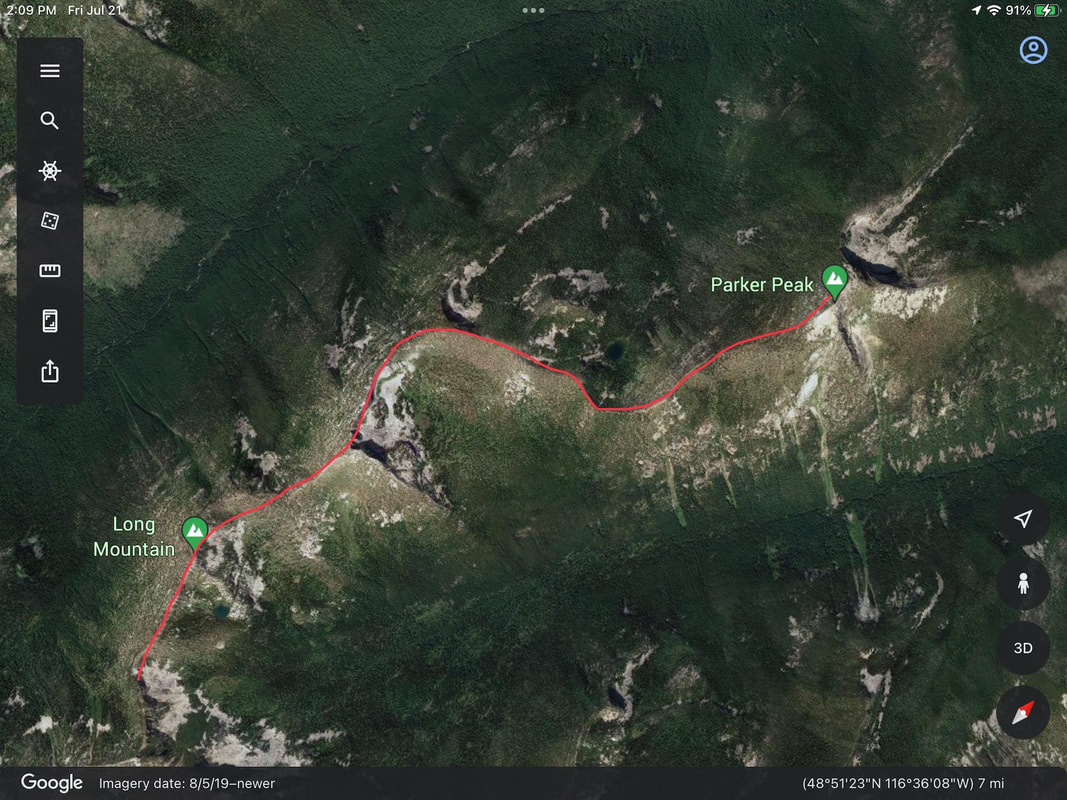 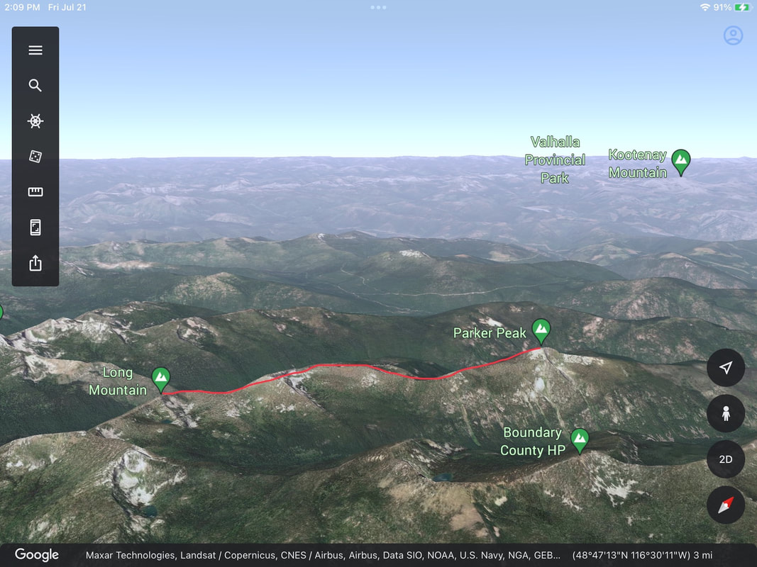 These show me what I need to know.
And as I’m walking the route, I can use the images to determine where I am and how far it is to a feature. Also for the phones, is an app that turns your phone into a rescue devise. Log onto AirFlare.com. Because AirFlare is an app, it weights nothing, and can send emergency coordinates to rescuers. If a partner is misplaced in the woods, AirFlare can communicate up to a quarter of a mile with them. AirFlare can operate on as little as one bar on your reception scale. But that isn’t the best part. It only costs $4.99 a year. Look into it. It could save you someday. But please remember, it takes a lot of time for the Sheriff to put together a rescue crew and get to you. By this I mean…if you are in a remote area, it may take them 3 to 6 hours, or more just to reach you. Check out the 13 ESSENTIALS drop down menu for info every hiker must have with them. InlandNWRoutes.com Chic Burge. David Crafton Mother Nature needs our help.
Below is a simple way we all can help. As we venture out to recreate, consider helping our region’s stewards maintain where we play. At campgrounds, trailheads, and trails please pick up any trash in your area visited. As you walk the trail, use your hiking poles to flick branches off the trail. A campground host just told me that when an area is littered, it tends to get more litter. But he went on to say…After he cleans an area it tends to stay cleaner longer. If that’s true, just think what you could do to enhance another’s visit. And who knows. You might profit from it. iNot to mention the pride you will feel after helping Mother Nature. It’s a simple chore, that others will notice. The unfortunate part is you will rarely hear about it, or get a Thank You. But they may tell their friends about how clean the area was. And that’s on you. So I would like to Thank You. Thank You for helping our place on this earth. InlandNWRoutes.com Chic Burge David Crafton So you plan a hike to your favorite area. Once at the trailhead, you find the USFS has closed the area or restricted specific activities within the area. DO NOT BLOW THIS WARNING OFF. This is an excerpt from a current closure notice, listed in that Ranger District’s website ALERTS  The USFS and other government agencies, post their closures and are serious about enforcement.
However, a recent closure did not explain the reason for the closure. This may lead visitors to violate the closure. Do not take any chances when you see these closures. For this reason, David and I have created a section in each write up that shows you places near by that are good alternatives to your original hike/outing. It’s called “COOL THINGS CLOSE BY:” Please refer to this section if you find yourself unable to hike as planned. Which illustrates the need to call each Ranger District, several days before your trip. Ask about closures, fires, road conditions, so you can plan your trip accordingly. Current closures are listed below, on our HOME PAGE. And to be sure our readers get the message, I’ve listed any closures orders under the events opening image. This all came about a few years ago when we drove 2.5 hours north, only to find that Boundary County was replacing a bridge a mere 400’ from the turn off. We had to get back to 95 and access the frontage road via Copeland, which is near the U.S.- Canadian boarder. It set our hike back 1.5 hours. Please plan your trip days in advance, then check InlandNWRoutes.com, and the USFS for any Forest ALERTS. THANK YOU, FOR BEING OUR READERS, InlandNWRoutes.com Chic Burge David Crafton HYDRATION
Water is as essential to life as oxygen. This BLOG will explain what you need to know, so you can plan ahead. There is a rule of thumb, that states: We can last 3 minutes without air. Three days without water. And three weeks without food. Depending on size As long as I can remember, there has been public arguments about how much water you should be drunk per day. In the sports we do, drinking enough water is paramount to sustaining our ability to preform. A good rule of thumb is to drink enough water not to experience thirst. If you do experience thirst, it’s already too late. Stop and rehydrate thoroughly before continuing. But do not over drink. Water toxicity can be as dangerous as not enough water. When you pee, notice the color of your urine. If your pee is a bright yellow, you could be dehydrated. If it’s clear, you may be out of danger. Examine your next pee and act accordingly. Purify water as you hydrate, so you can stay hydrated Our blood gets thicker as we get drier. And that’s not good. I realize that carrying enough water is heavy, so I carry a light weight purifier like Sawyer Mini Filter. The whole kit is only 5 ounces. They claim 100,000 gallon lifetime, with proper care. It has a 16oz. collapsible flask that can be filled in a hurry, so you can continue on. I use an empty pop bottle that will screw into the filter. I always have at least two bottles of water with me. One is a pop bottle. I also feel that if you have to dig for, or have someone get you your water bottle out, you may not be hydrating often enough. Find a water bottle holder so it’s always within reach. Keep an eye on your hiking partners. If they are not drinking enough water, they may be in trouble. It is your responsibility to keep your self hydrated, and watch over your hiking partners. Drinking too much in a short time, can reduce your electrolytes to dangerous levels. Last year while leading a hike to Two Mouth Lakes in the American Selkirks, I started to crash. One of the hikers is a fitness instructor and recognized my condition. Another hiker gave me an electrolyte packet, that brought me back in minutes. InlandNWRoutes.com Chic Burge David Crafton |
AuthorWe would like to engage our users so we have started this blog so that we can interact with you. Please do not hesitate to comment on our posts if you have questions or things to add. BLOG ENTRY INDEX
Archives
April 2024
Categories |
 RSS Feed