DOME MOUNTAIN 7560’ TRAIL #360
EVENT TYPE: Day hiking, backpacking, loop
DISTANCE: 14 miles RT
ELEVATION GAIN: 1646 verts, from upper Cedar Lake
DIFFICULTY: Difficult
MAPS: Kootenai N.F., Crowell Creek topo
GPS: 48°21’44” N 115°45’09” W
Libby Ranger District: 208.293.7773
LINCOLN COUNTY SHERIFF: CALL 911 FIRST or 406.293.4112
DISTANCE: 14 miles RT
ELEVATION GAIN: 1646 verts, from upper Cedar Lake
DIFFICULTY: Difficult
MAPS: Kootenai N.F., Crowell Creek topo
GPS: 48°21’44” N 115°45’09” W
Libby Ranger District: 208.293.7773
LINCOLN COUNTY SHERIFF: CALL 911 FIRST or 406.293.4112
DESCRIPTION:
WE HAVE ADDED THE AREAS SHERIFF’S EMERGENCY PHONE NUMBERS FOR EACH TRIP WRITE UP UNDER THE RANGER DISTRICT INFO. IF AN EMERGENCY OCURRS, EVALUATE YOUR CIRCUMSTANCES AND CALL ONLY IF NEEDED.
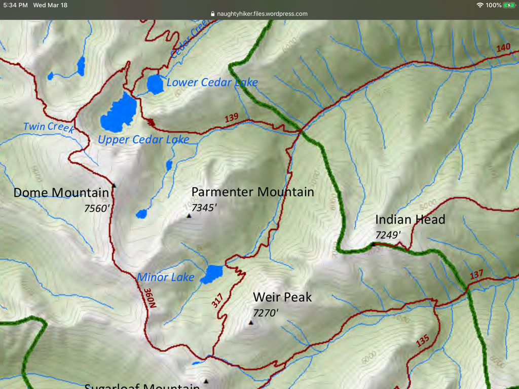
First you hike the Cedar Lakes trail to the upper lake. Then Trail #360 rounds the Upper Cedar Lake to the west on its way to Dome Mountain.
Most of the trail is on scree to the summit.
First you hike the Cedar Lakes trail to the upper lake. Then Trail #360 rounds the Upper Cedar Lake to the west on its way to Dome Mountain.
Most of the trail is on scree to the summit.
OPTION #1:
One of the cool things about this hike, is it’s connection with several trails that form about a 25 mile loop hike mostly up high. Consult a CMW forest map to plan your trip.
Peaks that are on this loop are, Sugarloaf Mountain, Weir Peak, and Parmenter Mountain
Peaks that are on this loop are, Sugarloaf Mountain, Weir Peak, and Parmenter Mountain
DIRECTIONS:
From Libby, head west on Highway 2 for about 3 miles and turn left (south) up Road # 402. Look for milepost # 27.7.
HAZARDS:
Rock hopping and scree near the summit.
COOL THINGS CLOSE BY:
Ross Creek Cedars, Cedar Lakes, Dome Mountain, Kootenai Falls, and the Proposed Scotchman Peaks Wilderness.
R & P:
Henry’s in Libby, Pizza Hut, Rosaeurs, Clark Fork Pantry & Squeeze Inn in Clark Fork. Eicharts, Mr Sub, Burger Express, & Jalapeños in Sandpoint
PHOTO GALLERY