PALOUSE FALLS STATE PARK HERITAGE SITE
WASHINGTON S.P. HAS ISSUED A CLOSURE FOR AREAS THAT HAVE CLIFFS PEOPLE CAN WALK ALONG AND THE 'CASTLES' NEAR THE TOP OF THE FALLS. WE CAN STILL WALK TO THE OBSERVATION AREA, BUT MUST STAY WITHIN THE FENCED AREA. 2.4.2022
EVENT TYPE: Camping, hiking, and sightseeing
DISTANCE: varies depending on your desires.
ELEVATION: minimal, unless you hike down to the Snake River level
DIFFICULTY: easy
MAPS: Palouse Falls State Park brochure, Palouse Falls & Starbucks W Topos
GPS: 46°39’50” N 118°13’38” W
MANAGING AGENCY: W.S.P.& R. 509.646.9218
COUNTY SHERIFF: Franklin CALL 911 FIRSTor 509.545.3501, Whitman 911 or 509.297.6266
DESCRIPTION:
Recently, Palouse Falls was designated by the Washington Legislature, as the State’s Waterfall.
From the viewing area, look for a trail to the north along the rim that overlooks the Palouse River.
BE EXTRA CAREFUL ALONG THE RIM. DEADLY FALLS HAVE HAPPENED.
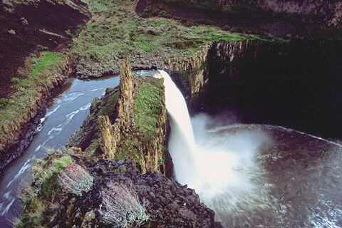
Keep heading along the rim as it turns NW to a narrow trail that leads down to the railroad tracks. Follow them until you find a trail dropping down a scree slope towards Upper Palouse Falls. From here the trail heads SSE along some basalt cliffs to the Castles. The Castles are the rock towers to the NW of the main falls.
WHILE AT THE CASTLES, BE EXTREMELY CAREFUL NEAR THE FALLS.
FALLS HAPPEN!
Retrace your steps back to the viewing area.
Heading the opposite direction is the Fryxell Overlook, in a short distance.
This overlook offers views of the falls as well as a fine view of the Palouse River Gorge, down stream.
Because the Palouse Falls S.P. is only 94 acres, parking and camping areas are tight on busy days. A Discovery Pass is required, or a one time entrance fee is collected.
Search youtube for Palouse Falls kayaker. You will be astounded.
• One sheltered picnic table with two braziers
• Seven unsheltered picnic tables
• Restrooms nearby the picnic and camping areas are available.
Palouse Falls is one of few active waterfalls left along this massive glacial flood path.
Palouse Falls has long been a location used by Native American tribes. The falls were first documented in 1841, during a survey of the region led by Captain Charles Wilkes of the United States Navy (U.S. Exploring Expedition).
Palouse Falls State Park was dedicated on June 3, 1951. The 94 acres that make up the park were donated by several parties, including The Baker-Boyer National Bank of Walla Walla, J.M. McGregor of the McGregor Land and Livestock Company, Mrs. Agnes Sells of Washtucna and others.
Palouse Falls was designated as the state waterfall by the Washington State legislature on March 18, 2014. The bill designating the waterfall.
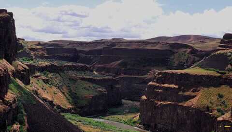
Within the dramatic flood-carved Palouse River Canyon, Palouse Falls is one of the key destinations along the Ice Age Floods National Geological Trail.
Please remember a Discover Pass is required to visit a state park.
History
Created by the Cordilleran ice age from glacial Lake Missoula more than 13,000 years ago,
The designation was written by 3rd, 4th, 5th and 6th grade students of the nearby Washtucna School.
Palouse Falls is one of few active waterfalls left along this massive glacial flood path. Perched
Palouse Falls has long been a location used by Native American tribes. The falls were first documented in 1841, during a survey of the region led by Captain Charles Wilkes of the United States Navy (U.S. Exploring Expedition).
Palouse Falls State Park was dedicated on June 3, 1951. The 94 acres that make up the park were donated by several parties, including The Baker-Boyer National Bank of Walla Walla, J.M. McGregor of the McGregor Land and Livestock Company, Mrs. Agnes Sells of Washtucna and others.
Palouse Falls was designated as the state waterfall by the Washington State legislature on March 18, 2014.
Park boundary within the dramatic flood-carved Palouse River Canyon, Palouse Falls is one of the key destinations along the Ice Age Floods National Geological Trail.
From the viewing area, look for a trail to the north along the rim that overlooks the Palouse River.
BE EXTRA CAREFUL ALONG THE RIM. DEADLY FALLS HAVE HAPPENED.
Keep heading along the rim as it turns NW to a narrow trail that leads down to the railroad tracks. Follow them until you find a trail dropping down a scree slope towards Upper Palouse Falls. From here the trail heads SSE along some basalt cliffs to the Castles. The Castles are the rock towers to the NW of the main falls.
WHILE AT THE CASTLES, BE EXTREMELY CAREFUL NEAR THE FALLS.
FALLS HAPPEN!
Retrace your steps back to the viewing area.
Heading the opposite direction is the Fryxell Overlook, in a short distance.
This overlook offers views of the falls as well as a fine view of the Palouse River Gorge, down stream.
Because the Palouse Falls S.P. is only 94 acres, parking and camping areas are tight on busy days. A Discovery Pass is required, or a one time entrance fee is collected.
Search youtube for Palouse Falls kayaker. You will be astounded.
• One sheltered picnic table with two braziers
• Seven unsheltered picnic tables
• Restrooms nearby the picnic and camping areas are available.
Palouse Falls is one of few active waterfalls left along this massive glacial flood path.
Palouse Falls has long been a location used by Native American tribes. The falls were first documented in 1841, during a survey of the region led by Captain Charles Wilkes of the United States Navy (U.S. Exploring Expedition).
Palouse Falls State Park was dedicated on June 3, 1951. The 94 acres that make up the park were donated by several parties, including The Baker-Boyer National Bank of Walla Walla, J.M. McGregor of the McGregor Land and Livestock Company, Mrs. Agnes Sells of Washtucna and others.
Palouse Falls was designated as the state waterfall by the Washington State legislature on March 18, 2014. The bill designating the waterfall.
Within the dramatic flood-carved Palouse River Canyon, Palouse Falls is one of the key destinations along the Ice Age Floods National Geological Trail.
Please remember a Discover Pass is required to visit a state park.
History
Created by the Cordilleran ice age from glacial Lake Missoula more than 13,000 years ago,
The designation was written by 3rd, 4th, 5th and 6th grade students of the nearby Washtucna School.
Palouse Falls is one of few active waterfalls left along this massive glacial flood path. Perched
Palouse Falls has long been a location used by Native American tribes. The falls were first documented in 1841, during a survey of the region led by Captain Charles Wilkes of the United States Navy (U.S. Exploring Expedition).
Palouse Falls State Park was dedicated on June 3, 1951. The 94 acres that make up the park were donated by several parties, including The Baker-Boyer National Bank of Walla Walla, J.M. McGregor of the McGregor Land and Livestock Company, Mrs. Agnes Sells of Washtucna and others.
Palouse Falls was designated as the state waterfall by the Washington State legislature on March 18, 2014.
Park boundary within the dramatic flood-carved Palouse River Canyon, Palouse Falls is one of the key destinations along the Ice Age Floods National Geological Trail.
DIRECTIONS:
From Spokane, head west on I-90 past Tokio to Hwy 261, and turn left down 251 to the Palouse Falls Highway sign. This road only goes to Palouse Falls.
HAZARDS:
THIS PARK REQUIRES GREAT CAUTION AND CARE.
Except in the viewing area, all other areas you go to, can be dangerous.
PLEASE USE EXTREME CAUTION WHILE AT PALOUSE FALLS.
Except in the viewing area, all other areas you go to, can be dangerous.
PLEASE USE EXTREME CAUTION WHILE AT PALOUSE FALLS.
COOL THINGS CLOSE BY:
Sun Lakes State Park & Dry Falls, Summer Falls, Escure Ranch, Bonnie Lake, Lions Ferry State Park, and the Snake River.
R & P:
Lenny’s in Cheney
PLAN YOUR TRIP:
Click for Current NOAA Weather Conditions
PHOTO GALLERY
THE ENERGIZER BUNNY
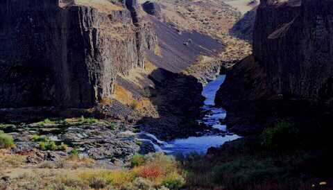
PALOUSE FALLS FROM NORTH TRAIL
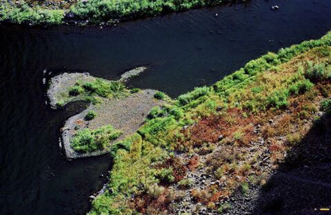
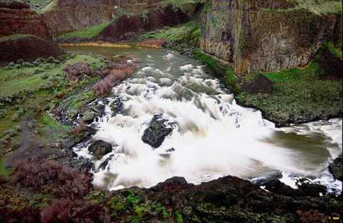
THE PALOUSE RIVER BETWEEN UPPER AND LOWER PALOUSE FALLS
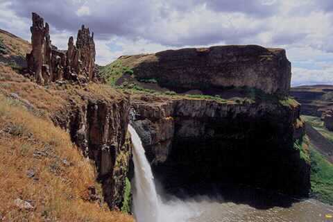
PALOUSE FALLS AND THE CASTLES FROM THE LOWER TRAIL
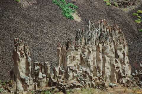
THE CASTLES NEAR THE MAIN FALLS
MIDDLE PALOUSE FALLS