BAYVIEW CITY LAUNCH
PADDLE DISTANCE: varies
ELEVATION: 2067’
LENGTH AND ACREAGE: 65 miles long, & 148 square miles and 1150’ deep.
MAPS: Bayview Topo
LAUNCH GPS: 47°58’50” N 116°33’30” W
KOOTENAI COUNTY SHERIFF: 208.446.1300
ELEVATION: 2067’
LENGTH AND ACREAGE: 65 miles long, & 148 square miles and 1150’ deep.
MAPS: Bayview Topo
LAUNCH GPS: 47°58’50” N 116°33’30” W
KOOTENAI COUNTY SHERIFF: 208.446.1300
DESCRIPTION:
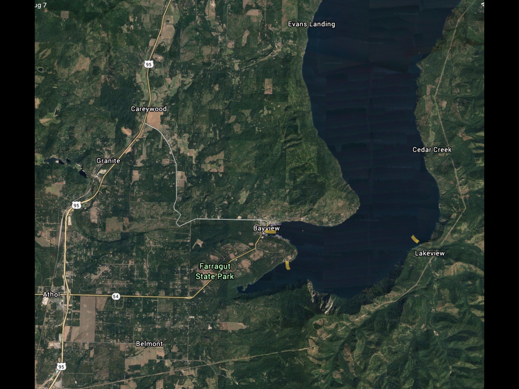
The Bayview Launch is located downtown across from the Bayview Mercantile, and next to the Boileau’s Buttonhook Inn.
From the launch, the main body of the lake is about 2 miles due east. Along the south shore line as the bay meets the lake is Blackwell Point.
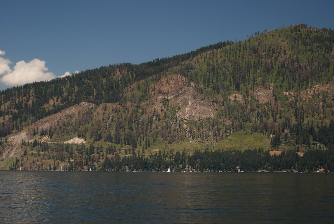
From Blackwell Point, paddle SSE across Idlewilde Bay to Steamboat Rock.
A WORD OF PRECAUTION ABOUT PADDLING LAKE PEND ORIELLE. IF THE WINDS ARE UP, DO NOT GO FAR FROM THE SHORE. IF YOU GET CAUGHT IN THE WINDS, GO TO THE NEAREST SHORE LINE WITHOUT BUCKING THE WINDS.
Steamboat Rock is just less then a mile across. As you approach Steamboat Rock, watch the hill side for Mountain Goats. Mountain Goats usually done climb around the cliffs above the lake in the heat of the day. So look for any very bright white specks on the cliffs.
As you skirt Steamboat Rock, massive cliffs dominate the shore line all the way to Echo Bay and beyond.
At 1.5 miles from Steamboat Rock, is Echo Bay. Echo Bay has the first “beaches” along the shore. I put beach in parentheses because the beaches are made up of polished flat rocks. Because of Echo Bay’s orientation, it doesn’t get full sun until late afternoon. Find a spot in the sun and have lunch and swim.
A WORD ON SANITATION....YOU CAN’T GET 200’ FROM THE WATER TO DO YOUR BUSINESS. SO, TAKE A PEE BOTTLE, AND BLUE BAGS FOR EACH PERSONS AND YOUR POOP. PLEASE DO NOT PEE IN THE LAKE.
There is something special you will find at Echo Bay. As stated above, the rocks are flat and polished. They are excellent rocks for skipping.
But beware, I’ve skipped so many rocks, my shoulders hurt to much to paddle.
After skipping too many rocks, you can follow your route back to Bayview. But you can also paddle north up to Lakeview. Lakeview is about 3 miles up lake.
BUT BE AWARE...IF THE WINDS ARE UP, DO NOT ATTEMPT TO PADDLE ACROSS THE LAKE TO BAYVIEW OR THE WEST SHORE LINE.
INSTEAD, FOLLOW YOUR ROUTE BACK TO STEAMBOAT ROCK, STAYING CLISE TO THE SHORE. ONCE YOU ARE AT STEAMBOAT ROCK, PAUSE BEFORE CROSSING IDLEWILDE BAY. FIND A SMALL SPOT ALONG THE SHORE, OUT OF THE WINDS, AND WAIT OUT THE WINDS.
DO NOT ATTEMPT THE CROSSING IN ANY WINDS YOU ARE NOT COMFORTABLE WITH.
OPTION #1:
From Blackwell Point, turn south (right) into Idlewilde Bay, along the shore and Farragut State Park. First you will come to Farrugut’s boat launch. There are toilets here if needed.
Continuing south , the shore line is spectacular. Near the south end of Pend Orielle Lake is Beaver Bay Beach and Swimming Area. Stop for a swim, but do not take your kayaks into the swimming area.
A bit further south is Buttonhook Bay and the end of the lake.
You can paddle the east shore line up to Steamboat Rock, and then across to Bayview.
OPTION #2:
Once out in Bayview’s bay, you can paddle up the west shore line around Cape Hope and beyond. Just don’t allow the winds to be in your face as you paddle back to Bayview.
OPTION #3:
Now the fun starts. This option is a four or five day paddle around the northern half of Lake Pend Orielle. Whether you launch from Bayview or Farragut, paddle across Idlewilde Bay to Steamboat Rock as noted above. But continue up Cedar Creek
The next leg takes you from Cedar Creek, to Granite Creek Landing. Because only about 14% of the shore line is privately owned, you can find a secluded beach to camp in private.
The third leg takes you across the lake to the west shore line, and Maiden Rock Boat Camp. Maiden Rock has an outhouse, picnic tables, and more of those wonderful skipping rocks. Not to mention rocks to climb and dive off of. Also at Maiden Rock, is a trail up to the Blacktail Trailhead and Mountain. It’s a steep 2 miles, but maybe a shorter walk up to the Cedar trees s enough.
But maybe to make the last leg shorter, it would be wise to paddle about 2 miles past Evans landing and boat camp. From 2 miles past Evans Landing, it’s over 8 miles to the Farragut Launch.
This total paddle loop is over 30 miles. Because of the distance, and the possibility of winds, you may want to let loved ones know you may be late getting home. Possibly a day late.
LEG ONE....8.4 miles ~
LEG TWO....6.4 miles ~
LEG THREE....8 miles ~
LEG FOUR....7 miles ~
ATTRACTIONS
So many to list.
Mountain Goats at two or more places, untouched shore line camping, cliffs, wildlife, BIG water paddling, beautiful shore lines, solitude, and best of all, incredible rock skipping.
Mountain Goats at two or more places, untouched shore line camping, cliffs, wildlife, BIG water paddling, beautiful shore lines, solitude, and best of all, incredible rock skipping.
DIRECTIONS:
Drive about 17.7 miles to the Athol exit, and turn right (East) onto Hwy 54. After stopping to pay for entry and overnight fees, get back onto Hwy 54 and drive about 1/4 mile to the South Road. Turn right (SE then NE) for about 3.2 miles to the launch.
COOL THINGS CLOSE BY:
Silverwood Theme Park. I only list this, because the more people at Silverwood, the less on the lake.
Other cool things are Lake Cocolalla, Packsaddle Mountain, Lakeview, and N. & S. Chilco Peaks
Other cool things are Lake Cocolalla, Packsaddle Mountain, Lakeview, and N. & S. Chilco Peaks
R & P:
Trails End Brewery, Mexican Food Factory, Franklins Hoagies, and the Moon Time.


