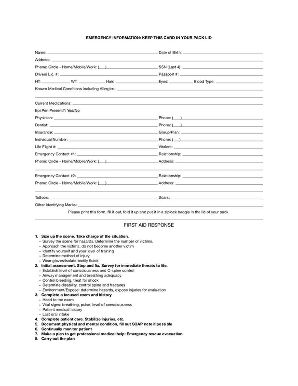
MEDICAL INFORMATION CARD
THE REASON WE SUGGEST CARRYING THIS CARD IS SIMPLE
IF YOU HAVE AN ISSUE IN THE MOUNTAINS,
MEDICAL PERSONNEL,
AS WELL AS HIKING BUDDIES,
NEED TO KNOW WHAT TO DO AND WHO TO CALL.
EVERYONE
SHOULD HAVE THIS FORM IN THEIR PACKS.
| medical_emergency_card.pdf |
MEDICAL INFORMATION
FREE, KINDA, CPR and FIRST AID
We all should know CPR and First Aid.
To learn more…log onto…cprandfirstaid.net.
Study the material and information, and take the test.
You could become someone’s hero.
HYDRATION
In the sports we do, drinking enough water is paramount to sustaining or ability to preform.
A good rule of thumb is to drink enough water not to experience thirst.
If you do experience thirst, it’s already too late.
Stop and rehydrate thoroughly before continuing. Our blood gets thicker as we get drier. And that’s not good.
I realize that carrying enough water is heavy, so carry a light weight purifier like Sawyer Mini Filter. It has a 16oz. collapsible flask that can be filled in a hurry, so you can continue on.
I always have at least two bottles of water with me. I also feel that if you have to dig for, or have someone get you your water, you may not hydrate often enough.
Find a water bottle holder so it’s always within reach.
The CDC recommends 43 ounces per day for adult females, and 44 ounces for males.
But when we hike, we should monitor our intake and drink enough water to NOT become thirsty.
FROSTBITE
Symptoms may include
Lack of feeling
Skin appears waxy, cold to the touch, can appear white, yellow or blue.
Warm slowly, and protect the affected area from getting cold.
CARE FOR FROSTBITE
Handle affected areas carefully
Immerse affected area in water between 100° and 105°. NEVER HOTTER. Pour water on the inside of your wrist, to test the warmth.
If you immerse, do not let any parts touch bucket sides or bottom.
After parts are warmed, put gauze or cotton between fingers or toes, then wrap loosely in sterile gauze.
If skin blisters, DO NOT POP THE BLISTER.
HYPOTHERMIA
It is everyone’s responsibility to stay warm in cold weather. It is also everyone’s responsibility to check on your sport buddies to make sure they are staying warm. If your partner takes their gloves off, or unzips the jacket, etc., this may be a sign that they are getting too cold.
If their speech become slurred or they are not thinking clearly, stop them and access their condition.
I have been on a trip in which a buddy got hypothermic in no time. She thot the claps of thunder, were people from Bonner’s Ferry bombing us for being there.
During hypothermia, one become complacent and doesn’t feel the cold. They may stop shivering, unzip their clothes and get even colder.
I always carry a thermos of hot water or tea in the winter.
It is imperative to get your buddy warm as fast as you can, but not with high heat.
His or her life may depend on YOU. Carry several chemical heaters, so you can warm their extremities. Then get down to your car as fast as you can.
Up at the Selkirks mentioned above, I draped her arm over my shoulder and walked and drug her down the trail.
Once you get to the car, you still aren’t out of trouble. Put water bottles up by the windshield heater, and drive as fast as you can, while being safe.
Get your partner to a hospital fast. During the drive, they may start to come around. Ask them questions that take thot to answer. If they fail, drive faster.
Put on your flashers, hold your horn on and BE AS SAFE AS YOU CAN WHILE DRIVING.
HYPOTHERMIA KILLS..and it kills slowly.
Your buddies life depends on YOU.
Signs of Hypothermia are, but not limited to:
Shivering
Slow pulse
Numbness
Glassy stare
Apathy and decrease in consciousness.
Person doesn’t have to be cold.
Take off any clothes that are wet.
Signs of worsening Hypothermia:
Slows or stops shivering
Slow Breathing
Undoes clothes
Things to do:
Warm slowly with blankets
Dry clothes
Warm environment
Can drink warm water cautiously
Things not to do:
Do not stop going to hospital unless buddy can answer hard question with ease.
Do not use rubbing alcohol on any affected area.
HEAT CRAMPS
Symptoms of heat cramps are heavy sweating during exercise, with muscle pains, spasms and cramps.
As with most health issues in the mountains, you must be able to see the symptoms in both you or any of your hiking partners. Take action fast.
Move the subject out of the sun, or to a cooler location. Give the person cool water to drink.
If you get leg cramps, try this idea. In a comfortable sitting position, extend your legs out, and slowly move your toes back and forth, until the cramps subside.
Something I carry for cramps is restaurant mustard packets. Take one orally and follow with water. The cramps will go away.
HEAT EXHAUSTION
There are a lot of symptoms for heat exhaustion. They include, but are not limited to the following.
Heavy sweating, cold, pale clammy skin, fast weak pulse, nausea, vomiting, muscle cramps, tiredness, weakness, dizziness, headaches, and fainting.
If you or your hiking partner are experiencing heat exhaustion, get them out of the sun, or shade them, use a creek to splash or dampen their clothes.
If their symptoms get worse, get them in the creek, then rush them to a hospital.
Apply cold towel or clothes to armpits, neck, and any large blood vessels.
Remove or loosen tight clothes.
HEAT STROKE
Heat Stroke is a very serious condition, and must be dealt with fast.
Symptoms include but aren’t limited to the following.
A temp of 103°+, altered mental state, odd behavior, on and off sweating, nausea, vomiting, flush skin, rapid breathing, a racing heart beat, and headaches.
You must move fast to cool this person. Get out of the sun, into the shade, dip their clothes in cold creek water and redress them. Immersion can cool a person quickly but you must not allow them to get real cold.
But most of all, do not allow a victim to drink water, until their temps are down. Watch for symptoms of shock
Apply cold towel or clothes to armpits, neck, and any large blood vessels.
Remove or loosen tight clothes
MEDICAL CLASSES
The Spokane Mountaineers offer a yearly Wilderness First Aid Certification Course, CPR Certification Course, and Altho not a medical class, it saves lives, a Level 1 Avalanche Course.
For further study, contact your local fire department, YWCA, YMCA, or local hospital. Classes are usually held every year.
Also, log onto….cprandfirstaid.net.
Study the information and take the test to see how you did.
Another resource I’ve used is…..cprandfirstaid.net.
Study the material, take the test.
Certification is optional.
THE MORE YOU KNOW, MEANS EVERYTHING c.
ACCIDENTS
In my 13 essentials kit, is a notebook and pen. Among other reasons, I keep notes on all aspects of the accident.
If you have to hurry out to get medical help, you might not remember exactly where the accident occurred.
Also include the victims name, age, details on the injury, vital signs, and any medical conditions the victim may suffer.
On your way out, mark the route you took to get out. Sometimes, the memory isn’t as exact as it needs to be.
When you have a moment, sit quietly, and write details of the accident.
Be very specific.
Also, if the injured hiking partner has their “Medical Info Card”, take it with you when you go for help. The more info the search and rescue folks have, the better the chances they will have, in getting to the victim, and field treating any issues.
Whomever you send out for help, be sure to tell that person to be extra careful getting out. If they get injured while hurrying, the original victim may suffer.
Preform a gentle injury evaluation of the victim. Assess the person carefully. And be sure not to cause any harm.
Stop all bleeding by using pressure on the wound. Use clean snow if it’s available. Elevate the area injured, but only if it won’t cause more discomfort.
Clear their throat, and check often.
Monitor the victims vital signs, and record the results and time you evaluated.
Keep the victim warm and safe. Watch for shock.
DO NO HARM
Look for a spot where a helicopter could land. Mark the area so the pilot can clearly see the landing spot.
When you have time, or have other hikers with you, clean the helicopter landing sight of any and all objects that may fly up and damage the helicopter’s blades.
Be sure to save the batteries in your headlight. You may need them later.
SPRAINED ANKLES
Sprain ankles can cause a big issue if you are way back on a trail.
From experience, I teach all hikers, an important lesson I learned while I was 5 miles up a trail, under the North Twin, in the American Selkirks.
My first sprain was bad, but by following the instructions below, I got up and walked out on my own. I was solo.
The second sprain that day was within 2 miles from the car. It took me 4 hours to walk that 2 miles.
If you sprain an ankle, drop to the ground. DO NOT STAY STANDING. DROP TO THE GROUND IMMEDIATELY, DO NOT TRY TO STOP YOUR FALL, BUT BE CAREFUL, AND STAY THERE, WITH YOUR SPRAINED ANKLE UP IN THE AIR.
After dropping to the ground, get your foot propped up on a high rock or tree, above your heart, straight up. And do not lower it for at least 30-45 minutes.
When I say drop to the ground, I mean, do not stop your fall. Go directly to the ground and get your foot up, and leave it there. If there is snow or a creek close by, use them to "ice" your injury. But do not lower your leg.
After 30 to 45 minutes, slowly, over several minutes, lower your leg. If the injury starts to pulse or ache as you lower it, raise your ankle back up. Repeat this until your ankle can manage the pain.
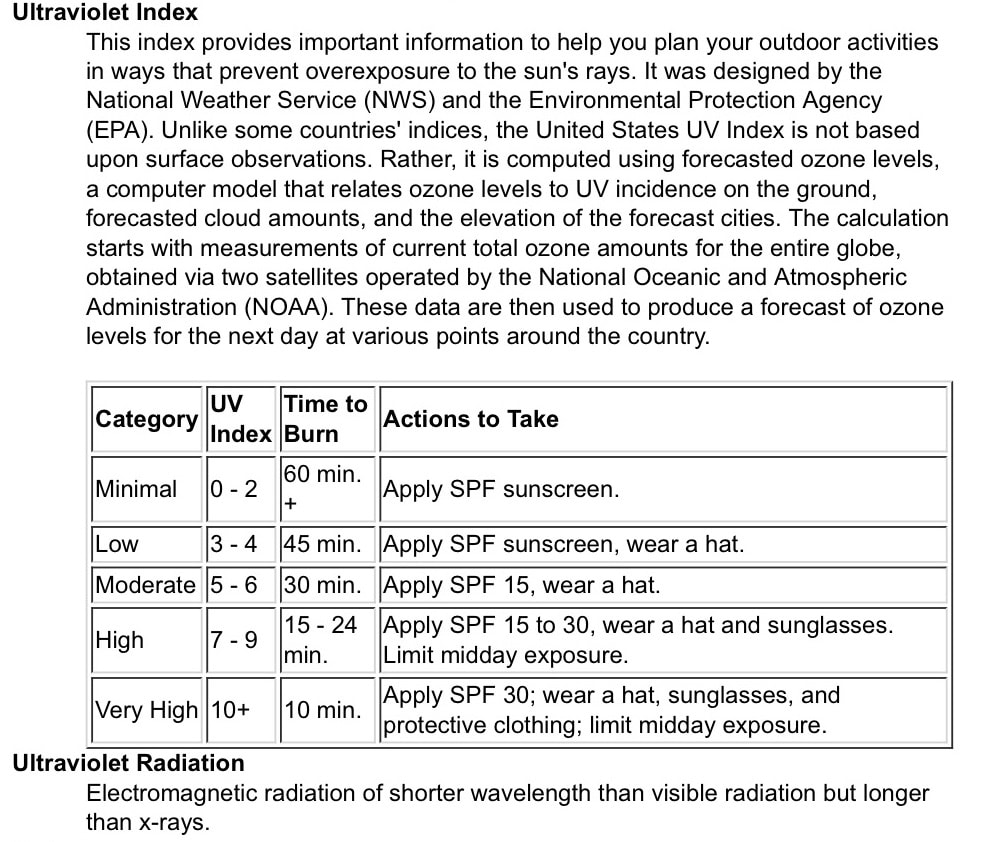
SUN EXPOSURE AND LOTION INFO
Ultraviolet Index
This index provides important information to help you plan your outdoor activities
in ways that prevent overexposure to the sun's rays. It was designed by the
National Weather Service (NWS) and the Environmental Protection Agency
(EPA). Unlike some countries' indices, the United States UV Index is not based
upon surface observations. Rather, it is computed using forecasted ozone levels,
a computer model that relates ozone levels to UV incidence on the ground,
forecasted cloud amounts, and the elevation of the forecast cities. The calculation
starts with measurements of current total ozone amounts for the entire globe,
obtained via two satellites operated by the National Oceanic and Atmospheric
Administration (NOAA). These data are then used to produce a forecast of ozone
levels for the next day at various points around the country.
We all should know CPR and First Aid.
To learn more…log onto…cprandfirstaid.net.
Study the material and information, and take the test.
You could become someone’s hero.
HYDRATION
In the sports we do, drinking enough water is paramount to sustaining or ability to preform.
A good rule of thumb is to drink enough water not to experience thirst.
If you do experience thirst, it’s already too late.
Stop and rehydrate thoroughly before continuing. Our blood gets thicker as we get drier. And that’s not good.
I realize that carrying enough water is heavy, so carry a light weight purifier like Sawyer Mini Filter. It has a 16oz. collapsible flask that can be filled in a hurry, so you can continue on.
I always have at least two bottles of water with me. I also feel that if you have to dig for, or have someone get you your water, you may not hydrate often enough.
Find a water bottle holder so it’s always within reach.
The CDC recommends 43 ounces per day for adult females, and 44 ounces for males.
But when we hike, we should monitor our intake and drink enough water to NOT become thirsty.
FROSTBITE
Symptoms may include
Lack of feeling
Skin appears waxy, cold to the touch, can appear white, yellow or blue.
Warm slowly, and protect the affected area from getting cold.
CARE FOR FROSTBITE
Handle affected areas carefully
Immerse affected area in water between 100° and 105°. NEVER HOTTER. Pour water on the inside of your wrist, to test the warmth.
If you immerse, do not let any parts touch bucket sides or bottom.
After parts are warmed, put gauze or cotton between fingers or toes, then wrap loosely in sterile gauze.
If skin blisters, DO NOT POP THE BLISTER.
HYPOTHERMIA
It is everyone’s responsibility to stay warm in cold weather. It is also everyone’s responsibility to check on your sport buddies to make sure they are staying warm. If your partner takes their gloves off, or unzips the jacket, etc., this may be a sign that they are getting too cold.
If their speech become slurred or they are not thinking clearly, stop them and access their condition.
I have been on a trip in which a buddy got hypothermic in no time. She thot the claps of thunder, were people from Bonner’s Ferry bombing us for being there.
During hypothermia, one become complacent and doesn’t feel the cold. They may stop shivering, unzip their clothes and get even colder.
I always carry a thermos of hot water or tea in the winter.
It is imperative to get your buddy warm as fast as you can, but not with high heat.
His or her life may depend on YOU. Carry several chemical heaters, so you can warm their extremities. Then get down to your car as fast as you can.
Up at the Selkirks mentioned above, I draped her arm over my shoulder and walked and drug her down the trail.
Once you get to the car, you still aren’t out of trouble. Put water bottles up by the windshield heater, and drive as fast as you can, while being safe.
Get your partner to a hospital fast. During the drive, they may start to come around. Ask them questions that take thot to answer. If they fail, drive faster.
Put on your flashers, hold your horn on and BE AS SAFE AS YOU CAN WHILE DRIVING.
HYPOTHERMIA KILLS..and it kills slowly.
Your buddies life depends on YOU.
Signs of Hypothermia are, but not limited to:
Shivering
Slow pulse
Numbness
Glassy stare
Apathy and decrease in consciousness.
Person doesn’t have to be cold.
Take off any clothes that are wet.
Signs of worsening Hypothermia:
Slows or stops shivering
Slow Breathing
Undoes clothes
Things to do:
Warm slowly with blankets
Dry clothes
Warm environment
Can drink warm water cautiously
Things not to do:
Do not stop going to hospital unless buddy can answer hard question with ease.
Do not use rubbing alcohol on any affected area.
HEAT CRAMPS
Symptoms of heat cramps are heavy sweating during exercise, with muscle pains, spasms and cramps.
As with most health issues in the mountains, you must be able to see the symptoms in both you or any of your hiking partners. Take action fast.
Move the subject out of the sun, or to a cooler location. Give the person cool water to drink.
If you get leg cramps, try this idea. In a comfortable sitting position, extend your legs out, and slowly move your toes back and forth, until the cramps subside.
Something I carry for cramps is restaurant mustard packets. Take one orally and follow with water. The cramps will go away.
HEAT EXHAUSTION
There are a lot of symptoms for heat exhaustion. They include, but are not limited to the following.
Heavy sweating, cold, pale clammy skin, fast weak pulse, nausea, vomiting, muscle cramps, tiredness, weakness, dizziness, headaches, and fainting.
If you or your hiking partner are experiencing heat exhaustion, get them out of the sun, or shade them, use a creek to splash or dampen their clothes.
If their symptoms get worse, get them in the creek, then rush them to a hospital.
Apply cold towel or clothes to armpits, neck, and any large blood vessels.
Remove or loosen tight clothes.
HEAT STROKE
Heat Stroke is a very serious condition, and must be dealt with fast.
Symptoms include but aren’t limited to the following.
A temp of 103°+, altered mental state, odd behavior, on and off sweating, nausea, vomiting, flush skin, rapid breathing, a racing heart beat, and headaches.
You must move fast to cool this person. Get out of the sun, into the shade, dip their clothes in cold creek water and redress them. Immersion can cool a person quickly but you must not allow them to get real cold.
But most of all, do not allow a victim to drink water, until their temps are down. Watch for symptoms of shock
Apply cold towel or clothes to armpits, neck, and any large blood vessels.
Remove or loosen tight clothes
MEDICAL CLASSES
The Spokane Mountaineers offer a yearly Wilderness First Aid Certification Course, CPR Certification Course, and Altho not a medical class, it saves lives, a Level 1 Avalanche Course.
For further study, contact your local fire department, YWCA, YMCA, or local hospital. Classes are usually held every year.
Also, log onto….cprandfirstaid.net.
Study the information and take the test to see how you did.
Another resource I’ve used is…..cprandfirstaid.net.
Study the material, take the test.
Certification is optional.
THE MORE YOU KNOW, MEANS EVERYTHING c.
ACCIDENTS
In my 13 essentials kit, is a notebook and pen. Among other reasons, I keep notes on all aspects of the accident.
If you have to hurry out to get medical help, you might not remember exactly where the accident occurred.
Also include the victims name, age, details on the injury, vital signs, and any medical conditions the victim may suffer.
On your way out, mark the route you took to get out. Sometimes, the memory isn’t as exact as it needs to be.
When you have a moment, sit quietly, and write details of the accident.
Be very specific.
Also, if the injured hiking partner has their “Medical Info Card”, take it with you when you go for help. The more info the search and rescue folks have, the better the chances they will have, in getting to the victim, and field treating any issues.
Whomever you send out for help, be sure to tell that person to be extra careful getting out. If they get injured while hurrying, the original victim may suffer.
Preform a gentle injury evaluation of the victim. Assess the person carefully. And be sure not to cause any harm.
Stop all bleeding by using pressure on the wound. Use clean snow if it’s available. Elevate the area injured, but only if it won’t cause more discomfort.
Clear their throat, and check often.
Monitor the victims vital signs, and record the results and time you evaluated.
Keep the victim warm and safe. Watch for shock.
DO NO HARM
Look for a spot where a helicopter could land. Mark the area so the pilot can clearly see the landing spot.
When you have time, or have other hikers with you, clean the helicopter landing sight of any and all objects that may fly up and damage the helicopter’s blades.
Be sure to save the batteries in your headlight. You may need them later.
SPRAINED ANKLES
Sprain ankles can cause a big issue if you are way back on a trail.
From experience, I teach all hikers, an important lesson I learned while I was 5 miles up a trail, under the North Twin, in the American Selkirks.
My first sprain was bad, but by following the instructions below, I got up and walked out on my own. I was solo.
The second sprain that day was within 2 miles from the car. It took me 4 hours to walk that 2 miles.
If you sprain an ankle, drop to the ground. DO NOT STAY STANDING. DROP TO THE GROUND IMMEDIATELY, DO NOT TRY TO STOP YOUR FALL, BUT BE CAREFUL, AND STAY THERE, WITH YOUR SPRAINED ANKLE UP IN THE AIR.
After dropping to the ground, get your foot propped up on a high rock or tree, above your heart, straight up. And do not lower it for at least 30-45 minutes.
When I say drop to the ground, I mean, do not stop your fall. Go directly to the ground and get your foot up, and leave it there. If there is snow or a creek close by, use them to "ice" your injury. But do not lower your leg.
After 30 to 45 minutes, slowly, over several minutes, lower your leg. If the injury starts to pulse or ache as you lower it, raise your ankle back up. Repeat this until your ankle can manage the pain.
SUN EXPOSURE AND LOTION INFO
Ultraviolet Index
This index provides important information to help you plan your outdoor activities
in ways that prevent overexposure to the sun's rays. It was designed by the
National Weather Service (NWS) and the Environmental Protection Agency
(EPA). Unlike some countries' indices, the United States UV Index is not based
upon surface observations. Rather, it is computed using forecasted ozone levels,
a computer model that relates ozone levels to UV incidence on the ground,
forecasted cloud amounts, and the elevation of the forecast cities. The calculation
starts with measurements of current total ozone amounts for the entire globe,
obtained via two satellites operated by the National Oceanic and Atmospheric
Administration (NOAA). These data are then used to produce a forecast of ozone
levels for the next day at various points around the country.
SUNSCREEN
Why You Need It. How it Works for You.
The big picture: Sunscreen is an important part of a complete sun protection strategy. But sunscreen alone isn’t enough to keep you safe in the sun.
When used as directed, sunscreen is proven to:
Decrease your risk of skin cancers and skin precancers. Regular daily use of SPF 15 sunscreen can reduce your risk of developing squamous cell carcinoma (SCC) by about 40 percent, and lower your melanoma risk by 50 percent.
Help prevent premature skin aging caused by the sun, including wrinkles, sagging and age spots.
WHO: Everyone under the sun
WHAT: Broad spectrum SPF 15 or higher; SPF 30 or higher for a day outdoors
WHEN: Every day; 30 minutes prior to going outdoors. Reapply every two hours
WHERE: All exposed skin
HOW: One ounce (shot glass full) to entire body for each application
WHY: Reduce your risk of skin damage and skin cancer!
Who should use sunscreen?
The short answer is everyone! Men, women and children over 6 months of age should use sunscreen every day. This includes people who tan easily and those who don’t — remember, your skin is damaged by sun exposure over your lifetime, whether or not you burn.
Babies under the age of 6 months are the only exceptions; their skin is highly sensitive. Stay out of the sun; shade structures and sun-protective clothing are the best ways to safeguard infants.
What type of sunscreen should you use?
With so many choices, how do you pick a sunscreen that’s right for you? The Skin Cancer Foundation believes that the best sunscreen is the one you are most likely to use, so long as it provides safe and effective protection, and is broad spectrum with an SPF 15 or higher. Learn about your options to make an informed choice that best suits your needs. The happier you are with your sunscreen, the more consistently you’ll use it.
Sunscreen ingredients
Sunscreen includes active ingredients that help prevent the sun’s UV radiation from reaching your skin. Here’s how the two types of sunscreen work for you:
Physical (mineral) sunscreen ingredients (including the minerals titanium dioxide and zinc oxide) block and scatter the rays before they penetrate your skin.
Chemical sunscreen ingredients (like avobenzone and octisalate) absorb UV rays before they can damage your skin.
Are sunscreens safe?
While physical sunscreens may be less likely to cause skin irritation than chemical sunscreens, both types have been tested as safe and effective. In fact, many sun protection products available today combine both types of ingredients.
All active ingredients in sunscreen are chemically derived. Some people may think of physical sunscreens as more “natural,” or even “organic,” but they’re actually inorganic mineral compounds. The sunscreens many people call “chemical” are actually “UV organic filters.”
What does SPF mean?
SPF stands for Sun Protection Factor. The number tells you how long the sun’s UVB rays would take to redden your skin if you apply the sunscreen exactly as directed compared with the amount of time without sunscreen. So, if you use an SPF 30 product properly, it would take you 30 times longer to burn than if you used no sunscreen.
What level of SPF do I need? If you’re inside most of the day with just short intervals in the sun, you can use a sunscreen or cosmetic product with an SPF of 15 or higher. If you spend a lot of time outdoors, especially when and where the sun is strongest, you need an SPF 30 or higher, water-resistant sunscreen. More about SPF.
No matter the SPF, reapplication every two hours is key. Sunscreen must also be reapplied immediately after swimming or sweating.
Broad-spectrum protection
In the past, most sunscreens only included information on product labels about protection against UVB — the rays that cause sunburn, and not UVA — the rays that cause tanning and premature aging. Now that UVA dangers are well known, broad-spectrum sunscreen provides clear information on product labels about protection against both UVB and UVA.
Choosing a sunscreen: What to look for
Broad spectrum: Protects your skin from both UVA and UVB rays.
When should I apply sunscreen?
Every day! The best practice is to apply 30 minutes before venturing outside to allow the sunscreen to bind to your skin. Reapply every two hours of exposure and immediately after swimming or excessive sweating.
Even when it’s cloudy, up to 80 percent of the sun’s UV radiation reaches the earth. Going unprotected on an overcast day can lead to skin damage.
Chic’s comment…..I apply a heavy coating before I leave home
Where should I apply sunscreen?
Experts recommend applying sunscreen to your entire body before you dress for the day. That way your skin will be protected if your clothing shifts or you remove layers. At the very least, you should use sunscreen on every part of your body that is exposed to the sun, including those easy-to-miss spots: the tops of your ears, back of your neck, your scalp (on the part line), tops of your feet and behind your knees.
How much sunscreen should I use?
To get the full broad-spectrum protection out of your sunscreen, apply one ounce — about a shot glass full — to your entire body. Most people apply less than half of that amount, translating into reduced protection. Learn more.
With reapplication, a family of four should use one four-ounce bottle of sunscreen per person during a long day outdoors.
Who should use sunscreen?
EVERYONE
Sunscreen reduces your overall UV exposure and lowers your risk of skin cancer and sun damage.
Other things to consider
Keep in mind that while crucial, sunscreen alone is not enough. Seek the shade whenever possible, wear sun-safe clothing, a wide-brimmed hat and UV-blocking sunglasses, for a complete sun protection strategy.
To help you select sun-safe products, look for the Skin Cancer Foundation’s Seal of Recommendation and browse our recommended sunscreen products.
For more prevention tips, see Your Daily Sun Protection Guide.
Reviewed by:
Elisabeth G. Richard, MD
Last updated: May 2021
PARTICULATE MATTER EXPLAINED
Particulate Matter (PM) BasicsOn This Page:
What is PM, and how does it get into the air?
Size comparisons for PM particlesPM stands for particulate matter (also called particle pollution): the term for a mixture of solid particles and liquid droplets found in the air. Some particles, such as dust, dirt, soot, or smoke, are large or dark enough to be seen with the naked eye. Others are so small they can only be detected using an electron microscope.
Particle pollution includes:
Some are emitted directly from a source, such as construction sites, unpaved roads, fields, smokestacks or fires.
Most particles form in the atmosphere as a result of complex reactions of chemicals such as sulfur dioxide and nitrogen oxides, which are pollutants emitted from power plants, industries and automobiles.
What are the Harmful Effects of PM?Particulate matter contains microscopic solids or liquid droplets that are so small that they can be inhaled and cause serious health problems. Some particles less than 10 micrometers in diameter can get deep into your lungs and some may even get into your bloodstream. Of these, particles less than 2.5 micrometers in diameter, also known as fine particles or PM2.5, pose the greatest risk to health.
Fine particles are also the main cause of reduced visibility (haze) in parts of the United States, including many of our treasured national parks and wilderness areas.
Learn more about health and environmental effects
What is Being Done to Reduce Particle Pollution?EPA regulates inhalable particles. Particles of sand and large dust, which are larger than 10 micrometers, are not regulated by EPA.
EPA’s national and regional rules to reduce emissions of pollutants that form PM will help state and local governments meet the Agency’s national air quality standards. Learn about how air quality standards help reduce PM.
How Can I Reduce My Exposure to PM?You can use air quality alerts to protect yourself and others when PM reaches harmful levels:
AirNow: Every day the Air Quality Index (AQI) tells you how clean or polluted your outdoor air is, along with associated health effects that may be of concern. The AQI translates air quality data into numbers and colors that help people understand when to take action to protect their health.
Fine Particles (PM 2.5) Questions and AnswersFine particulate matter (PM2.5) is an air pollutant that is a concern for people's health when levels in air are high. PM2.5 are tiny particles in the air that reduce visibility and cause the air to appear hazy when levels are elevated. Outdoor PM2.5 levels are most likely to be elevated on days with little or no wind or air mixing. The New York State Departments of Health (DOH) and Environmental Conservation (DEC) alert the public by issuing a PM2.5 Health Advisory when PM2.5 concentrations in outdoor air are expected to be unhealthy for sensitive groups.
What is Particulate Matter 2.5 (PM2.5)?The term fine particles, or particulate matter 2.5 (PM2.5), refers to tiny particles or droplets in the air that are two and one half microns or less in width. Like inches, meters and miles, a micron is a unit of measurement for distance. There are about 25,000 microns in an inch. The widths of the larger particles in the PM2.5 size range would be about thirty times smaller than that of a human hair. The smaller particles are so small that several thousand of them could fit on the period at the end of this sentence.
How can PM2.5 affect my health?Particles in the PM2.5 size range are able to travel deeply into the respiratory tract, reaching the lungs. Exposure to fine particles can cause short-term health effects such as eye, nose, throat and lung irritation, coughing, sneezing, runny nose and shortness of breath. Exposure to fine particles can also affect lung function and worsen medical conditions such as asthma and heart disease. Scientific studies have linked increases in daily PM2.5 exposure with increased respiratory and cardiovascular hospital admissions, emergency department visits and deaths. Studies also suggest that long term exposure to fine particulate matter may be associated with increased rates of chronic bronchitis, reduced lung function and increased mortality from lung cancer and heart disease. People with breathing and heart problems, children and the elderly may be particularly sensitive to PM2.5.
Where does PM2.5 come from?There are outdoor and indoor sources of fine particles. Outside, fine particles primarily come from car, truck, bus and off-road vehicle (e.g., construction equipment, snowmobile, locomotive) exhausts, other operations that involve the burning of fuels such as wood, heating oil or coal and natural sources such as forest and grass fires. Fine particles also form from the reaction of gases or droplets in the atmosphere from sources such as power plants. These chemical reactions can occur miles from the original source of the emissions. In New York State, some of the fine particles measured in the air are carried by wind from out-of-state sources. Because fine particles can be carried long distances from their source, events such as wildfires or volcanic eruptions can raise fine particle concentrations hundreds of miles from the event.
PM2.5 is also produced by common indoor activities. Some indoor sources of fine particles are tobacco smoke, cooking (e.g., frying, sautéing, and broiling), burning candles or oil lamps, and operating fireplaces and fuel-burning space heaters (e.g., kerosene heaters).
Is there an air quality standard for PM2.5 in outdoor air?Yes, the United States Environmental Protection Agency (EPA) established National Ambient Air Quality Standards for PM2.5 in 1997 and revised them in 2006 and 2012. National Ambient Air Standards are established to be protective of public health. The short-term standard (24-hour or daily average) is 35 micrograms per cubic meter of air (µg/m3) and the long-term standard (annual average) is 12 µg/m3. A microgram is a unit of weight. There are a million micrograms in a gram, and a pound is equal to about 450 grams.
How will I know when PM2.5 levels are, or will be, elevated outside?Outdoor air levels of fine particles increase during periods of stagnant air (very little wind and air mixing), when the particles are not carried away by wind, or when winds bring polluted air into the state from sources outside the state. In general, as the levels of PM2.5 in outdoor air increase, the air appears hazy and visibility is reduced. These conditions are similar in appearance to high humidity or fog. The New York State Department Environmental Conservation informs the public whenever fine particle concentrations in outdoor air are expected to be elevated. Every weekday morning the Department of Environmental Conservation will review weather conditions and data from their air monitoring stations to determine if, for that day or the following day, fine particle levels are expected to exceed levels considered unhealthy for sensitive groups. If it is likely that this level will be exceeded, the agency will contact the media so that a Particulate Matter Health Advisory can be carried on afternoon and evening broadcasts. The Department of Environmental Conservation also provides PM2.5 monitoring data and PM2.5 forecasts on its web site.
Are there ways to reduce my exposure to PM2.5?When outdoor levels of PM2.5 are elevated, going indoors may reduce your exposure, although some outdoor particles will come indoors. If there are significant indoor sources of PM2.5, levels inside may not be lower than outside. Some ways to reduce exposure are to limit indoor and outdoor activities that produce fine particles (for example, burning candles indoors or open burning outdoors) and avoid strenuous activity in areas where fine particle levels are high.
Who can I contact if I have more questions?If you would like additional information about the health effects of fine particles, you can call the NYS Department of Health at 518-402-7800or 800-458-1158. To find out if an advisory has been issued or to learn more about air quality, you can call the Department of Environmental Conservation's toll-free air quality hotline: 1-800-535-1345 or visit their Air Quality Index (AQI) website where you can also view state PM2.5maps and real-time monitoring data for PM2.5.
Why You Need It. How it Works for You.
The big picture: Sunscreen is an important part of a complete sun protection strategy. But sunscreen alone isn’t enough to keep you safe in the sun.
When used as directed, sunscreen is proven to:
Decrease your risk of skin cancers and skin precancers. Regular daily use of SPF 15 sunscreen can reduce your risk of developing squamous cell carcinoma (SCC) by about 40 percent, and lower your melanoma risk by 50 percent.
Help prevent premature skin aging caused by the sun, including wrinkles, sagging and age spots.
- Who should use sunscreen?
- What type of sunscreen should I use?
- When should I apply sunscreen?
- Where should I apply sunscreen?
- How much sunscreen should I use?
- Why should I use sunscreen?
WHO: Everyone under the sun
WHAT: Broad spectrum SPF 15 or higher; SPF 30 or higher for a day outdoors
WHEN: Every day; 30 minutes prior to going outdoors. Reapply every two hours
WHERE: All exposed skin
HOW: One ounce (shot glass full) to entire body for each application
WHY: Reduce your risk of skin damage and skin cancer!
Who should use sunscreen?
The short answer is everyone! Men, women and children over 6 months of age should use sunscreen every day. This includes people who tan easily and those who don’t — remember, your skin is damaged by sun exposure over your lifetime, whether or not you burn.
Babies under the age of 6 months are the only exceptions; their skin is highly sensitive. Stay out of the sun; shade structures and sun-protective clothing are the best ways to safeguard infants.
What type of sunscreen should you use?
With so many choices, how do you pick a sunscreen that’s right for you? The Skin Cancer Foundation believes that the best sunscreen is the one you are most likely to use, so long as it provides safe and effective protection, and is broad spectrum with an SPF 15 or higher. Learn about your options to make an informed choice that best suits your needs. The happier you are with your sunscreen, the more consistently you’ll use it.
Sunscreen ingredients
Sunscreen includes active ingredients that help prevent the sun’s UV radiation from reaching your skin. Here’s how the two types of sunscreen work for you:
Physical (mineral) sunscreen ingredients (including the minerals titanium dioxide and zinc oxide) block and scatter the rays before they penetrate your skin.
Chemical sunscreen ingredients (like avobenzone and octisalate) absorb UV rays before they can damage your skin.
Are sunscreens safe?
While physical sunscreens may be less likely to cause skin irritation than chemical sunscreens, both types have been tested as safe and effective. In fact, many sun protection products available today combine both types of ingredients.
All active ingredients in sunscreen are chemically derived. Some people may think of physical sunscreens as more “natural,” or even “organic,” but they’re actually inorganic mineral compounds. The sunscreens many people call “chemical” are actually “UV organic filters.”
What does SPF mean?
SPF stands for Sun Protection Factor. The number tells you how long the sun’s UVB rays would take to redden your skin if you apply the sunscreen exactly as directed compared with the amount of time without sunscreen. So, if you use an SPF 30 product properly, it would take you 30 times longer to burn than if you used no sunscreen.
What level of SPF do I need? If you’re inside most of the day with just short intervals in the sun, you can use a sunscreen or cosmetic product with an SPF of 15 or higher. If you spend a lot of time outdoors, especially when and where the sun is strongest, you need an SPF 30 or higher, water-resistant sunscreen. More about SPF.
No matter the SPF, reapplication every two hours is key. Sunscreen must also be reapplied immediately after swimming or sweating.
Broad-spectrum protection
In the past, most sunscreens only included information on product labels about protection against UVB — the rays that cause sunburn, and not UVA — the rays that cause tanning and premature aging. Now that UVA dangers are well known, broad-spectrum sunscreen provides clear information on product labels about protection against both UVB and UVA.
Choosing a sunscreen: What to look for
Broad spectrum: Protects your skin from both UVA and UVB rays.
When should I apply sunscreen?
Every day! The best practice is to apply 30 minutes before venturing outside to allow the sunscreen to bind to your skin. Reapply every two hours of exposure and immediately after swimming or excessive sweating.
Even when it’s cloudy, up to 80 percent of the sun’s UV radiation reaches the earth. Going unprotected on an overcast day can lead to skin damage.
Chic’s comment…..I apply a heavy coating before I leave home
Where should I apply sunscreen?
Experts recommend applying sunscreen to your entire body before you dress for the day. That way your skin will be protected if your clothing shifts or you remove layers. At the very least, you should use sunscreen on every part of your body that is exposed to the sun, including those easy-to-miss spots: the tops of your ears, back of your neck, your scalp (on the part line), tops of your feet and behind your knees.
How much sunscreen should I use?
To get the full broad-spectrum protection out of your sunscreen, apply one ounce — about a shot glass full — to your entire body. Most people apply less than half of that amount, translating into reduced protection. Learn more.
With reapplication, a family of four should use one four-ounce bottle of sunscreen per person during a long day outdoors.
Who should use sunscreen?
EVERYONE
Sunscreen reduces your overall UV exposure and lowers your risk of skin cancer and sun damage.
Other things to consider
- Your skin cancer risk factors: Your skin type and family history will determine the level of protection needed for you.
- Photosensitivity: No matter your skin type, certain medications and disorders make your skin highly sensitive to the sun, raising your protection requirements.
- Skin conditions: You can choose from sunscreens for dry skin, oily skin, acne-prone skin and sensitive skin.
Keep in mind that while crucial, sunscreen alone is not enough. Seek the shade whenever possible, wear sun-safe clothing, a wide-brimmed hat and UV-blocking sunglasses, for a complete sun protection strategy.
To help you select sun-safe products, look for the Skin Cancer Foundation’s Seal of Recommendation and browse our recommended sunscreen products.
For more prevention tips, see Your Daily Sun Protection Guide.
Reviewed by:
Elisabeth G. Richard, MD
Last updated: May 2021
PARTICULATE MATTER EXPLAINED
Particulate Matter (PM) BasicsOn This Page:
- What is PM, and how does it get into the air?
- What are the harmful effects of PM?
- What is being done to reduce particle pollution?
What is PM, and how does it get into the air?
Size comparisons for PM particlesPM stands for particulate matter (also called particle pollution): the term for a mixture of solid particles and liquid droplets found in the air. Some particles, such as dust, dirt, soot, or smoke, are large or dark enough to be seen with the naked eye. Others are so small they can only be detected using an electron microscope.
Particle pollution includes:
- PM10 : inhalable particles, with diameters that are generally 10 micrometers and smaller; and
- PM2.5 : fine inhalable particles, with diameters that are generally 2.5 micrometers and smaller.
- How small is 2.5 micrometers? Think about a single hair from your head. The average human hair is about 70 micrometers in diameter – making it 30 times larger than the largest fine particle.
Some are emitted directly from a source, such as construction sites, unpaved roads, fields, smokestacks or fires.
Most particles form in the atmosphere as a result of complex reactions of chemicals such as sulfur dioxide and nitrogen oxides, which are pollutants emitted from power plants, industries and automobiles.
What are the Harmful Effects of PM?Particulate matter contains microscopic solids or liquid droplets that are so small that they can be inhaled and cause serious health problems. Some particles less than 10 micrometers in diameter can get deep into your lungs and some may even get into your bloodstream. Of these, particles less than 2.5 micrometers in diameter, also known as fine particles or PM2.5, pose the greatest risk to health.
Fine particles are also the main cause of reduced visibility (haze) in parts of the United States, including many of our treasured national parks and wilderness areas.
Learn more about health and environmental effects
What is Being Done to Reduce Particle Pollution?EPA regulates inhalable particles. Particles of sand and large dust, which are larger than 10 micrometers, are not regulated by EPA.
EPA’s national and regional rules to reduce emissions of pollutants that form PM will help state and local governments meet the Agency’s national air quality standards. Learn about how air quality standards help reduce PM.
How Can I Reduce My Exposure to PM?You can use air quality alerts to protect yourself and others when PM reaches harmful levels:
AirNow: Every day the Air Quality Index (AQI) tells you how clean or polluted your outdoor air is, along with associated health effects that may be of concern. The AQI translates air quality data into numbers and colors that help people understand when to take action to protect their health.
- Go to About AirNow to learn how you can get AQI notifications.
- Also learn how the Air Quality Flag Program can help air agencies, schools, and other community organizations to notify their citizens of harmful conditions and adjust outdoor physical activities as needed.
Fine Particles (PM 2.5) Questions and AnswersFine particulate matter (PM2.5) is an air pollutant that is a concern for people's health when levels in air are high. PM2.5 are tiny particles in the air that reduce visibility and cause the air to appear hazy when levels are elevated. Outdoor PM2.5 levels are most likely to be elevated on days with little or no wind or air mixing. The New York State Departments of Health (DOH) and Environmental Conservation (DEC) alert the public by issuing a PM2.5 Health Advisory when PM2.5 concentrations in outdoor air are expected to be unhealthy for sensitive groups.
What is Particulate Matter 2.5 (PM2.5)?The term fine particles, or particulate matter 2.5 (PM2.5), refers to tiny particles or droplets in the air that are two and one half microns or less in width. Like inches, meters and miles, a micron is a unit of measurement for distance. There are about 25,000 microns in an inch. The widths of the larger particles in the PM2.5 size range would be about thirty times smaller than that of a human hair. The smaller particles are so small that several thousand of them could fit on the period at the end of this sentence.
How can PM2.5 affect my health?Particles in the PM2.5 size range are able to travel deeply into the respiratory tract, reaching the lungs. Exposure to fine particles can cause short-term health effects such as eye, nose, throat and lung irritation, coughing, sneezing, runny nose and shortness of breath. Exposure to fine particles can also affect lung function and worsen medical conditions such as asthma and heart disease. Scientific studies have linked increases in daily PM2.5 exposure with increased respiratory and cardiovascular hospital admissions, emergency department visits and deaths. Studies also suggest that long term exposure to fine particulate matter may be associated with increased rates of chronic bronchitis, reduced lung function and increased mortality from lung cancer and heart disease. People with breathing and heart problems, children and the elderly may be particularly sensitive to PM2.5.
Where does PM2.5 come from?There are outdoor and indoor sources of fine particles. Outside, fine particles primarily come from car, truck, bus and off-road vehicle (e.g., construction equipment, snowmobile, locomotive) exhausts, other operations that involve the burning of fuels such as wood, heating oil or coal and natural sources such as forest and grass fires. Fine particles also form from the reaction of gases or droplets in the atmosphere from sources such as power plants. These chemical reactions can occur miles from the original source of the emissions. In New York State, some of the fine particles measured in the air are carried by wind from out-of-state sources. Because fine particles can be carried long distances from their source, events such as wildfires or volcanic eruptions can raise fine particle concentrations hundreds of miles from the event.
PM2.5 is also produced by common indoor activities. Some indoor sources of fine particles are tobacco smoke, cooking (e.g., frying, sautéing, and broiling), burning candles or oil lamps, and operating fireplaces and fuel-burning space heaters (e.g., kerosene heaters).
Is there an air quality standard for PM2.5 in outdoor air?Yes, the United States Environmental Protection Agency (EPA) established National Ambient Air Quality Standards for PM2.5 in 1997 and revised them in 2006 and 2012. National Ambient Air Standards are established to be protective of public health. The short-term standard (24-hour or daily average) is 35 micrograms per cubic meter of air (µg/m3) and the long-term standard (annual average) is 12 µg/m3. A microgram is a unit of weight. There are a million micrograms in a gram, and a pound is equal to about 450 grams.
How will I know when PM2.5 levels are, or will be, elevated outside?Outdoor air levels of fine particles increase during periods of stagnant air (very little wind and air mixing), when the particles are not carried away by wind, or when winds bring polluted air into the state from sources outside the state. In general, as the levels of PM2.5 in outdoor air increase, the air appears hazy and visibility is reduced. These conditions are similar in appearance to high humidity or fog. The New York State Department Environmental Conservation informs the public whenever fine particle concentrations in outdoor air are expected to be elevated. Every weekday morning the Department of Environmental Conservation will review weather conditions and data from their air monitoring stations to determine if, for that day or the following day, fine particle levels are expected to exceed levels considered unhealthy for sensitive groups. If it is likely that this level will be exceeded, the agency will contact the media so that a Particulate Matter Health Advisory can be carried on afternoon and evening broadcasts. The Department of Environmental Conservation also provides PM2.5 monitoring data and PM2.5 forecasts on its web site.
Are there ways to reduce my exposure to PM2.5?When outdoor levels of PM2.5 are elevated, going indoors may reduce your exposure, although some outdoor particles will come indoors. If there are significant indoor sources of PM2.5, levels inside may not be lower than outside. Some ways to reduce exposure are to limit indoor and outdoor activities that produce fine particles (for example, burning candles indoors or open burning outdoors) and avoid strenuous activity in areas where fine particle levels are high.
Who can I contact if I have more questions?If you would like additional information about the health effects of fine particles, you can call the NYS Department of Health at 518-402-7800or 800-458-1158. To find out if an advisory has been issued or to learn more about air quality, you can call the Department of Environmental Conservation's toll-free air quality hotline: 1-800-535-1345 or visit their Air Quality Index (AQI) website where you can also view state PM2.5maps and real-time monitoring data for PM2.5.

