WANLESS LAKE TRAIL #912 & 912A
EVENT TYPE: Fast day hiking, backpacking
DISTANCE: 26 miles RT
ELEVATION: 2500’
DIFFICULTY: Strenuous
MAPS: Kootenai N.F., Noxon Rapids, Howard Lake, Goat Peak
GPS: Swamp Creek Trailhead. 47°55’02” N 115°37’00” W
RANGER DISTRICT: Cabinet Ranger District 406.827.3533
LINCOLN COUNTY SHERIFF: CALL 911 FIRST or 406.293.4112
DISTANCE: 26 miles RT
ELEVATION: 2500’
DIFFICULTY: Strenuous
MAPS: Kootenai N.F., Noxon Rapids, Howard Lake, Goat Peak
GPS: Swamp Creek Trailhead. 47°55’02” N 115°37’00” W
RANGER DISTRICT: Cabinet Ranger District 406.827.3533
LINCOLN COUNTY SHERIFF: CALL 911 FIRST or 406.293.4112
DESCRIPTION:
SWAMP CREEK TRAIL #912
I haven’t hiked Trail #912, but can offer some incite.
Gleaned from the USFS WEBPAGE
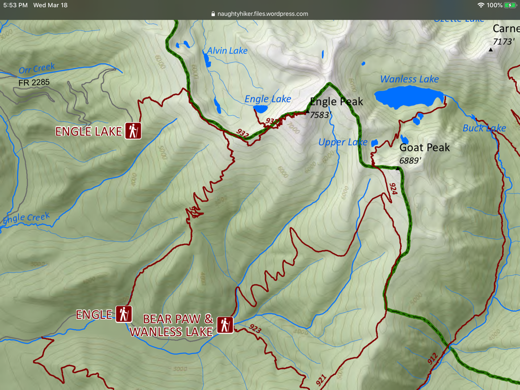
The Cabinet Mountain Wilderness follows Swamp Creek drainage to Lost Buck Pass and Trail #912A ends at Buck Lake. From Lost Buck Pass, Lake Creek Trail #656 drops to Upper & Lower Geiger Lakes, and South Divide Trail #360A flows a major ridge line out to the southern boundary of the C.M.W. Buck Lake Trail #912A ends at Buck Lake where there are a couple of diverse campsites and the lake contains small cutthroat trout.
Swamp Creek Trail #912: 12.13 miles one way Buck lake Trail #912A: .38 miles one way
Beginning: 2686’ Ending: 4389’ at Buck Lake. 5907’ at Lost Buck Pass Net gain: 1703’ to Buck Lake. 3221’ to Lost Buck Pass.
More difficult
Parking is available at the trailhead at the end of FSR 1119. The parking area is sufficient to turn around a large horse trailer and a hitch rail is available.
From MT Hwy 200, just west of milepost 27, turn north onto Swamp Creek Road. Travel approximately 4 miles to the end of the road and the trailhead.
Both Swamp Creek Trail #912 and Buck Lake Trail #912A are Trail Class 3 trails. The trail tread and corridor will be very well defined and visible. Trail #912 up to the junction with #912A is cleared every year. The portion of Trail #912 up to Lost Buck Pass is cleared every three years. Trail #912A is cleared every year. Please contact Cabinet Ranger Station for current trail conditions.
Howard Lake #89, Goat Peak #102 47.917 -115.616
The trail crosses Swamp Creek at approximately the 8 mile mark. This is a major stream crossing that can be challenging and dangerous for most of the year. There are other minor stream crossings that usually do not pose any major difficulties for travelers.
No motorized or mechanized vehicles.
Properly possess and store all food, refuse, and other attractants pursuant to Kootenai National Forest Food Storage Order (CFR 261.58 (cc)).
Please practice Pack-in-Pack-out and Leave-No-Trace ethics.
OPTION #1:
At the end of Trail #912, Trail #912A switchbacks East up 4 long legs to Trail #360A to Lost Buck Pass. Geiger Lakes lie below.
Above Lost Buck Pass, is Carney Peak 7173’, and a nice scramble to its summit, with incredible views.
Above Lost Buck Pass, is Carney Peak 7173’, and a nice scramble to its summit, with incredible views.
DIRECTIONS:
From MT Hwy 200, just west of milepost 27, turn north onto Swamp Creek Road. Travel approximately 4 miles to the end of the road and the trailhead.
HAZARDS:
This trail takes 6 hours plus to get to Buck Lake, if you are a strong hiker.
At about 8 miles, the trail crosses Swamp Creek, which can be tricky any time of the year.
At about 8 miles, the trail crosses Swamp Creek, which can be tricky any time of the year.
COOL THINGS CLOSE BY:
MCKAY Creek Road #1022
Take Hwy 200, to 3 miles past the Noxon Bridge to the McKay Creek Road #1022. It’s turn off is opposite the Noxon Rapids Viewpoint. Turn left NE and drive 4 miles to the trailhead.
Take Hwy 200, to 3 miles past the Noxon Bridge to the McKay Creek Road #1022. It’s turn off is opposite the Noxon Rapids Viewpoint. Turn left NE and drive 4 miles to the trailhead.
R & P:
Henry’s & Pizza Hut, in Libby, Clark Fork Pantry, Eicharts, Mr Sub & Jalapeños in Sandpoint
PLAN YOUR TRIP:
Click for Current NOAA Weather Conditions


