WATERFALL : Towell Falls DROP: Lower 12' & Upper 20' WATERFALL TYPE: Lower Cascade & Plunge DISTANCE CAR TO FALLS: 5 miles one way MAPS: BLM Brochure GPS: Trailhead 47°00’51” N 117°56'’36” W. Falls. 46°58'58" N 117°55'55" W
DESCRIPTION:
When you drive west on Hwy 20, I-90, or Hwy 26, you notice the area looks vacant and dry. But it is when you stop along your travels, you notice a very unique landscape. This whole area west of Spokane is the way it is because of the Glacier Lake Missoula Floods. As you walk off the road just a ways, imagine a wall of water 1,000 feet tall, moving at 55 mph from the east, scouring the landscape to bedrock. The floods removed about 1,000' of "top soil" along it's path. But those great floods didn't wash away everything. But rather created a landscape unique to Idaho, Washington and Northern Oregon. For further info on the great floods, double click WASHINGTON SCABLANDS in the HIKE drop down menu. This will bring up the story of the floods and how they happened. Escure Ranch and the Towell Falls area is a great example of what the floods destroyed then created. As you drive down to the trailhead near the ranch building, all around you is evidence of the floods. Before or after your hike out to Towell Falls, wonder across the bridge and take a look at the old homestead, barns, and outbuildings. You will notice that they were built to last not just decades but centuries. The BLM wanting to protect the heritage of the building, so they installed heavy metal grates on the ranch house. Wonder the area, and see what it took to ranch in this environment.
A SPECIAL NOTE ON HIKING IN THE WASHINGTON SCABLANDS. This terrain is different from around Spokane and the mountains of Eastern Washington and N. Idaho. YOU MUST pay very close attention to the terrain. Often stop and converse with your hiking partner(s) about visual landmarks, road junctions and other visual features. You have a camera phone, use it to record the terrain, mesas, road junctions and other details that will help you find your way back. Especially after leaving the waterfalls and heading back. I will supply a Google Earth map below if you don't follow the right path from the falls. THIS IS MY OPINION..DO NOT DRINK OR EVEN FILTER THIS WATER. MOST THE WATER IN THE SCABS IS AGRICULTURE RUNOFF. TAKE ALL YOU WILL NEED FOR DRINKING AND COOKING.
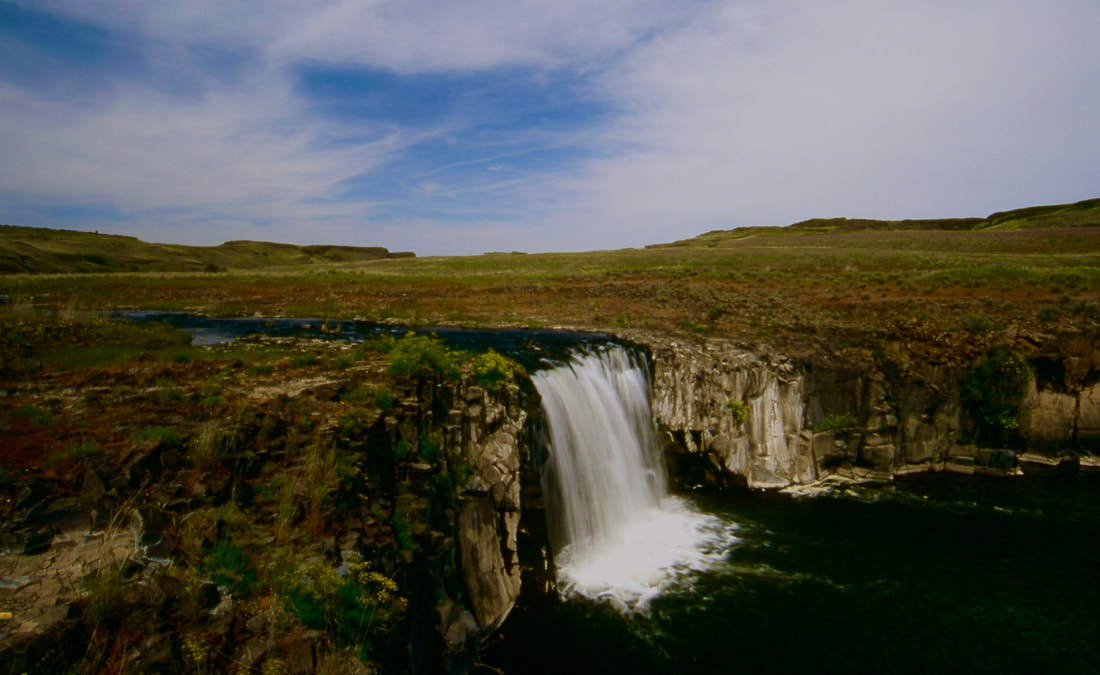
After touring the ranch buildings, go thru the gate by the parking area. Please shut all gates firmly behind you. The trail to the falls is an old road for about 3.2 miles, but only gains 530 feet. The trail follows Rock Creek, but sometimes its not in your view. Near the path leading down to the falls, you will hear and see the falls off to the west. FROM THIS POINT ON, PAY VERY CLOSE ATTENTION TO THE TRAIL AS IT DESCEND TO THE FALLS. YOU WILL NEED TO FOLOW IT BACK UP FROM THE FALLS EXACTLY. The path winds its way down to the falls and the island it sits on (depending on the season). When you first get to the lunch tree, turn your party around and examine the route you took to get down from the road you hiked in on. As you near the falls, during high water (a relative term) you will have to cross a small stream to get to both falls. There's a tree to have lunch under, just NW on the island. Lower Towell Falls will be obvious because of the sounds, but is real close to your lunch tree. All the rock around the area is basalt, so be very careful when you walk down to view the front of the falls. This falls is about 20-25 feet wide and drops about 15 feet as a Block waterfalls. Once you viewed the lower falls, walk north on the island. There are two intermittent cascades that drop off the east side , but often are dry. Continue your walk a bit further north and the Upper Falls will come into view. This falls is taller then the lower falls, but in my opinion, is much more beautiful. It plunges without touching the face it goes over. Spend some time here examining the basalt rock around the falls. Images of these falls with the scabs in the background, make for some great shots.
Now, you have to pay attention. In order not to take the wrong route away from the falls. collectively agree on your ascent away from the falls. Once at the road you hiked in on, turn left (N) and follow the road back out.
OPTION #1:
On the north side of Rock Creek, there is a primitive trail, mostly used by fisher persons. You can access this cross country trail by crossing over the bridge towards the buildings. At first there is a resemblance of a trail, but it diminishes the further you hike. This is where you MUST pay attention to the terrain, landmarks and where you walk. In my decades of hiking in the Scabs, this route is the only route I've ever encountered a rattlesnake. There are lower leg wraps to prevent snake bites. A rattlesnake will only strike if you threaten them. In the morning, or cool days they come out into the sun to warm themselves. Do not step over rocks, shrubs, or terrain where you can't see where your foot is landing. They might be sunning themselves. But they could be anywhere in the Scabs.
Continue hiking near Rock Creek but not right next to it. This route is not marked and requires constant observation of the terrain. When you eventually get to Towell Falls, you will be on the opposite side from the write up above. The views are different, but just as good as the other side. On your return, try to follow your route in, but wondering offers you great views along the way.
DIRECTIONS:
Take I-90 to Sprague, and exit at 245, then head south thru Sprague on S.R. 23 towards St. John and Steptoe. About 12 miles from Sprague turn left, then right onto Davis Road. In less then 7 miles turn left onto Jordon-Knot Road. Head south a little over 2 miles and cross over Rock Creek, then turn right into the Rock Creek Management Area. Continue 2.4 miles down to the trailhead. You may see other signs to the Esscure Ranch, but follow the instructions above.
COOL THINGS CLOSE BY:
While driving thru Sprague, take a moment to go down town and wonder thru Dave's Antique Car & Truck Museum. Palouse Falls, Lyons Ferry State Park, the Snake River, and the Juniper Dunes Wilderness
HAZARDS:
ALL WATERFALLS ARE A HAZARD, DUE TO THEIR SLIPPERY NATURE. ALWAYS BE EXTRA CAREFUL NEAR ANY WATERFALL.
As stated above, hiking in the Scabs can be dangerous, but very rewarding. Observe all terminal features, and discuss them all with your hiking partner(S). Always be on the lookout for rattlesnakes. Practice wise hiking. I've seen Badgers on the trail to the falls. Stear clear. Give them space. Wait for them to move on. DO Not try to challenge them to move, you will loose.
R & P:
NA
PLAN YOUR TRIP:
Click for Current NOAA Weather Conditions
PHOTO GALLERY
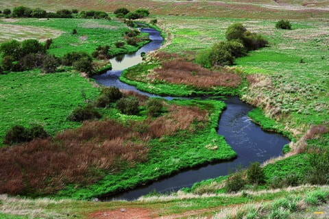
ROCK CREEK FROM THE BRIDGE
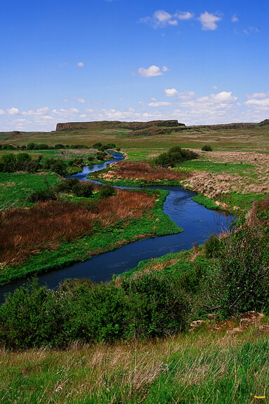
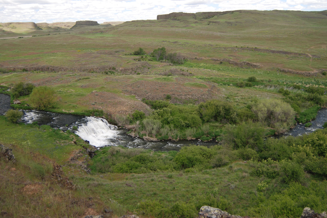
ROCK CREEK. NOTICE THE MESA IN THE BACKGROUND. THIS IS A TERRAIN FEATURE LIKE OTHERS YOU SHOULD REMEMBER
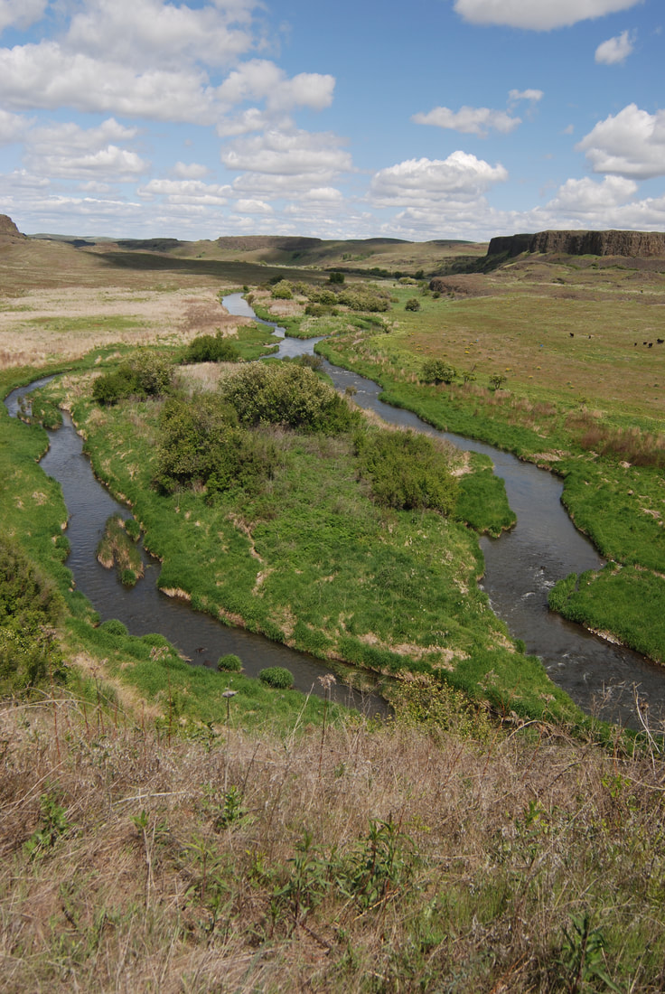
ROCK CREEK FURTHER IN
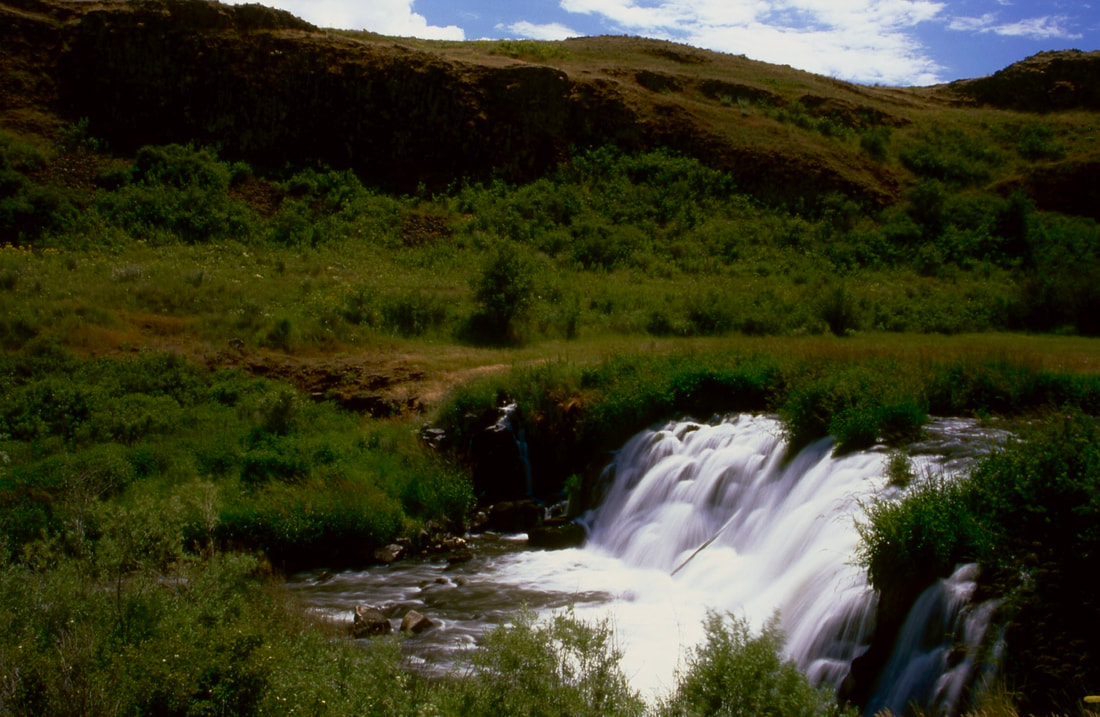
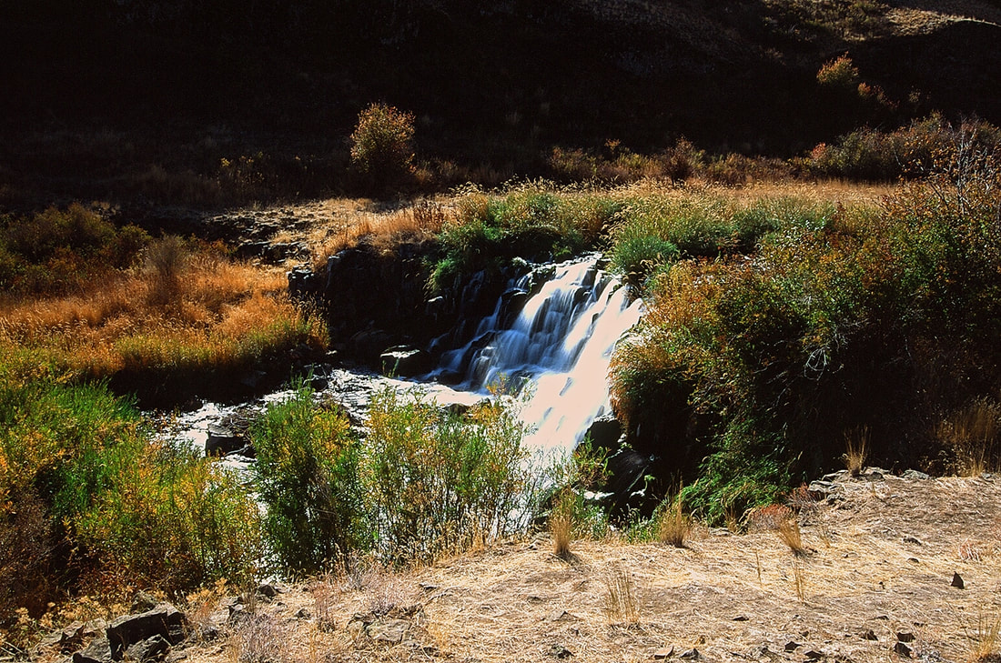
TOWELL FALLS FROM IT'S SMALL ISLAND
LOWER TOWELL FALLS IN THE SPRING
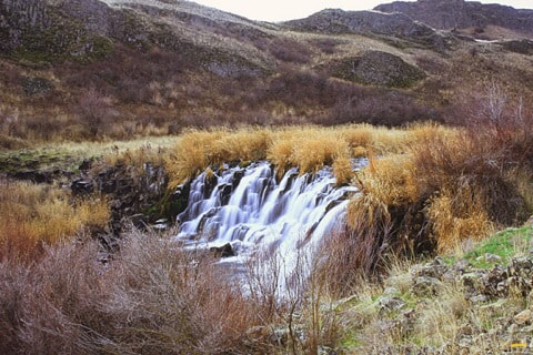
LOWER TOWELL FALLS IN NOVEMBER HIKING IS A BIT SAFER IN THE WINTER MONTHS BECAUSE OF THE COLD RATTLESNAKE ARE LESS PREVALENT
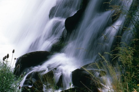
THE FALLS DROP OFF BASALT COLUMNS, CAUSING MANY CASCADES WITHIN THE GREATER FALLS
LOWER FALLS FACE ON IN NOVEMBER
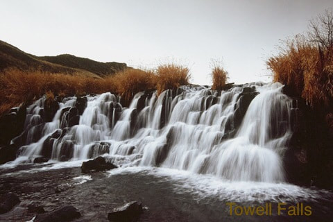
UPPER TOWELL FALLS IN THE SUMMER NOTICE THE TERRAIN FEATURES IN THE BACKGROUND
LOWER TOWELL FALLS FROM THE NORTHERN ROUTE
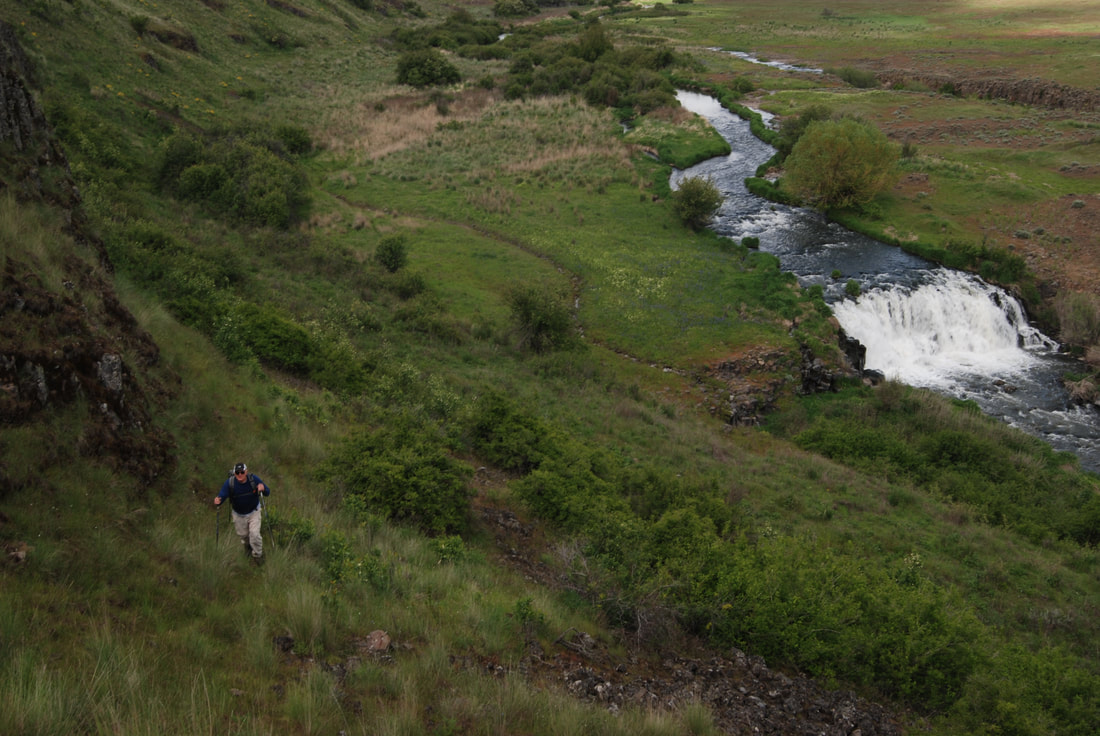
GALEN HIKING ABOVE TO VIEW THE FALLS FROM A DIFFERENT ANGLE