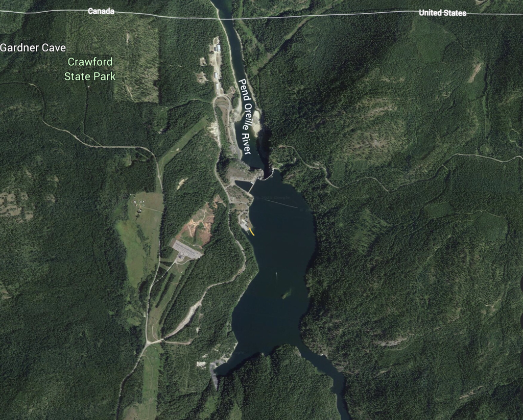
PADDLE DISTANCE: 17.5 miles RIVER ELEVATION: 1990’ LENGTH AND ACREAGE: NA MAPS: BLM maps & brochures, Colville National Forest, Metaline Falls & Boundary Dam topos. LAUNCH GPS: 48°58’58”N 117°21’02” W PEND ORIELLE COUNTY SHERIFF: 509.447.3151
DESCRIPTION:
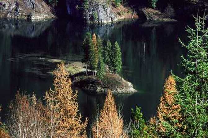
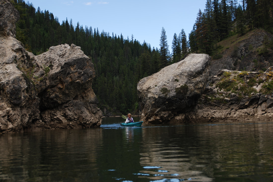
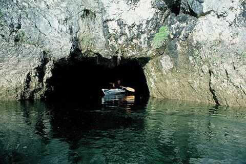
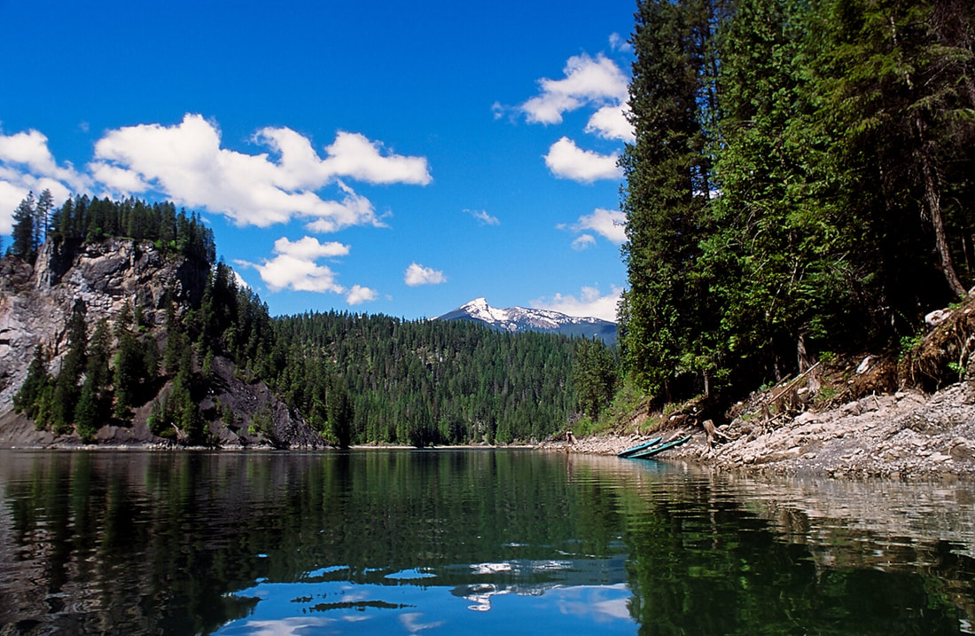
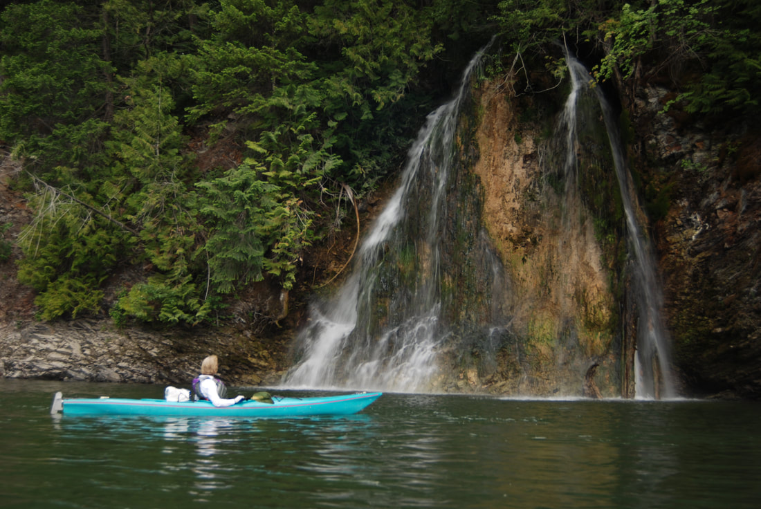
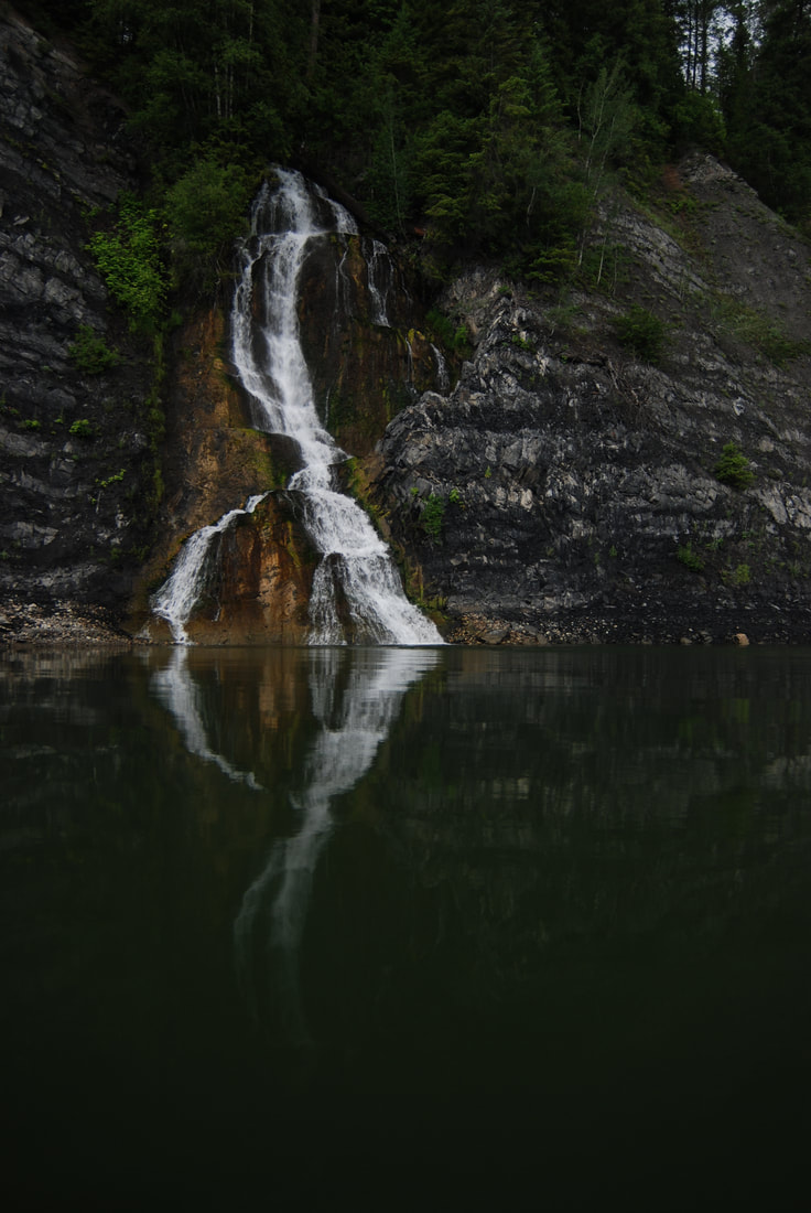
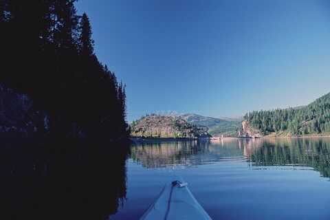
WE HAVE ADDED THE AREAS SHERIFF’S EMERGENCY PHONE NUMBERS FOR EACH TRIP WRITE UP UNDER THE RANGER DISTRICT INFO. IF AN EMERGENCY OCURRS, EVALUATE YOUR CIRCUMSTANCES AND CALL ONLY IF NEEDED. I prefer to launch at the Boundary Dam launch, because it’s located in the Boundary Dam camp sites. (See the end for my reason to launch here.) As you leave the dam site and launch, head over to Ratt Island first. In the morning, the dams are making power for Seattle. So the island is about half submerged. Later in the day, swing by the island. The dam has made power all day, hence the water levels are lower. And more of the island are above the water level. In the morning, Wildflowers are under water. After enjoying Ratt Island, head SW for about .6 of a mile to Pewee Falls. Because of the change in water levels during the day, the plunge pool, has a large round area of rocks that have dropped off the cliffs above. In the morning, this rock circle is under water. After leaving the bay that Pewee Falls is in, hug the right (west) shore line, paddling up stream, which in this case is south. The Z Canyon walls are hundreds of feet tall right out of the water. In the afternoon, there are two caves that appear after the water level drops. They are on the left (East). Continuing south up stream, three mikes from the launch is another larger island to paddle around. West of the island is a spot to stop for lunch, with picnic tables. About 7 mikes up stream from the launch, is one of the most spectacular sights and sounds on the Pend Orielle River. Look for two waterfalls, one on each side. As you hear the sounds, position your boat in the middle of the river and listen for stereophonic waterfalls. You are about 7.7 miles from the launch. If you want to continue and camp, there is a nice camp site at about 9.3 miles. A WORD OF CAUTION...because the water levels fluctuate about 5 to 16 feet every day, pull your boats up very high from the water line. Years ago, I led a paddle trip to this area to camp. At 5:30am, one of the crew got up to use the facilities. She was shocked, and woke us all up in a panic. The morning water level floated our boats. Only one was close, caught in an shore line Eddie. We rescued a kayak, and he went to get one nearby boat. Then two kayakers paddled fast to reclaim the rogue floaters. During breakfast, we all had a good laugh. But we all learned a huge lesson. Sleep and stow your boats at least 16’ above the evening water levels. From this camp site, there is a narrow channel heading up stream towards a Metaline Falls and beyond. I personally do not paddle down stream from the town of Metaline. Right after you go under the Metaline Falls bridge, there is an obstruction in the river that makes this section very dangerous. Decades ago, after the Box Canyon Dam and Boundary Dam were built, they decided to use explosives to bring down the old powerhouse. After the dust settled, they discovered that a huge section of rock, came down with the powerhouse. This obstruction causes a whirlpool on the east side of the river. I’m just not comfortable to paddle near the whirlpool. So, from the camp site, head north, down stream, back the way you came. Along the paddle back to Boundary Dam, notice the unusual rock formations all the way back to the launch.
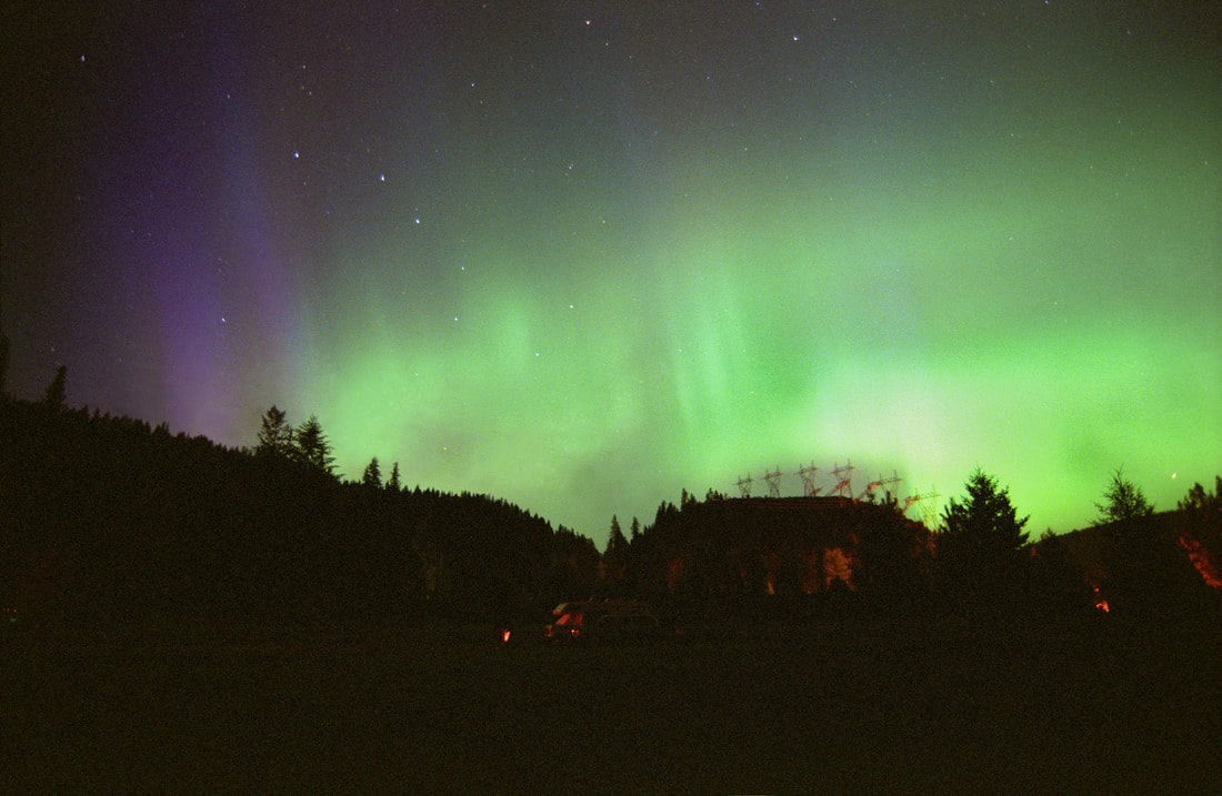
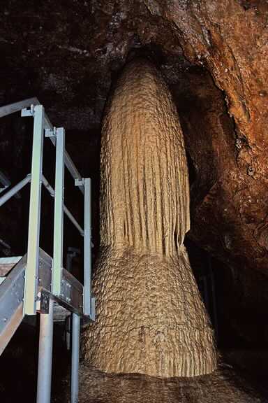
Ratt Island, 200’ tall Pewee Falls, two caves, 300’+ walls, and the most beautiful paddle in our region. During the summer months, Gardner Caves in The Crawford State Park, are not to be missed. Below is an image f a Christmas tree cave feature in the cave. Also, if the dam folks are doing tours of the dam, don’t miss it. Across the dam from the launch site is the Boundary Dam Vista House. You may be able to walk across the dam and up to the Vista House. Don’t miss this view. It looks back at the spillway across the river. There is a road to it, but you can’t drive across the bridge. You have to drive down to Sullivan Lake to reach it. While camping in the area, watch for auroras from about 10pm on. They may appear to the north over the massive power lines.
DIRECTIONS:
From Spokane, take U.S. Highway 2 north. Just past the Pend Oreille County line turn northwest for WA-211 toward Usk. Just before Usk, join Highway 20 north to Tiger, following the Pend Oreille River. At Tiger, continue north on WA-31 to Metaline. Just north of Metaline, turn west on Boundary Road and follow the signs to Crawford State Park. Discover Pass required.
COOL THINGS CLOSE BY:
Crawford Caves, Gardner State Park, Sullivan Lake, Priest Lakes, and the American Selkirks. Also, the drive from Metaline to Boundary Dam is an exceptional fall color drive.
RATT ISLAND, PEND ORIELLE RIVER DURING LOW “TIDE”.
RATT ISLAND DURING HIGH TIDE
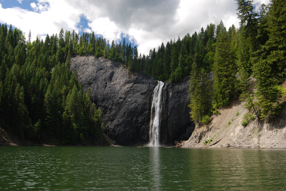
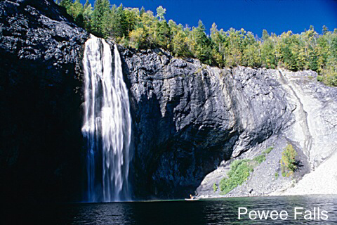
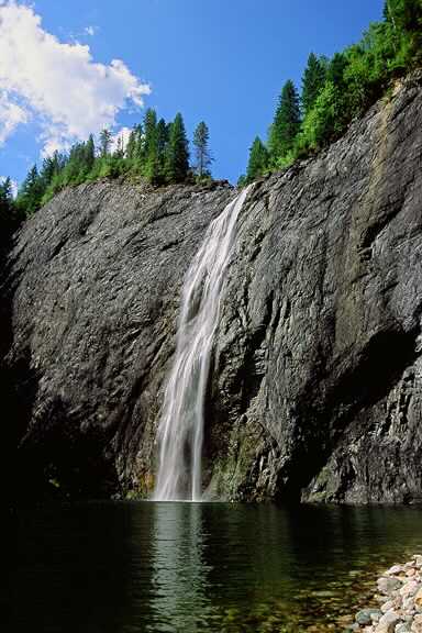
PEWEE FALLS AS YOU ENTER THE BAY THAT IT'S IN
200 FOOT PEWEE FALLS
PEWEE FALLS
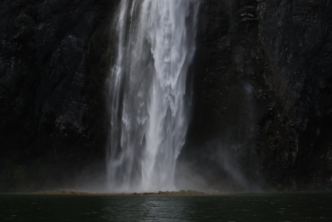
PEWEE FALLS DURING LOW TIDE. NOTICE THE HUGE ROCK PILE BENETH THE FALLS.
AT ONE TIME, THERE USED TO BE A NATURAL ARCH TO PADDLE UNDER. BUT THE COUNTY COMMISSIONERS THOT IT WOULD BE OKAY TO ALLOW JET BOAT TOURS. HENCE THE ARCH IS NO LONGER STANDING
ONE OF TWO CAVES TO PADDLE INTO.
THE PEND ORIELLE RIVER WITH HOOKNOSE ABOVE
MICHELLE PAUSES TO ADMIRE ONE OF THE TWO WATERFALLS ALONG THE RIVER.
ON THE OPPOSITE SIDE OF THE RIVER IS THIS WATERFALLS. IF YOU SET YOUR PADDLE DOWN AND CLOSE YOUR EYES, THE SOUNDS OF THE TWIN FALLS ON EACH SIDE OF THE RIVER, PRODUCE A STEREOPHONIC EFFECT THAT YOU CAN MEDITATE TO.
BOUNDARY DAM’S ELECTRICAL POWERLINES
BOUNDARY DAM FROM THE VISTA HOUSE ACROSS THE RIVER
FIVE TURBINES MAKING POWER FOR SEATTLE
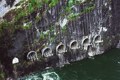
POWERLINE EXIT PORTAL
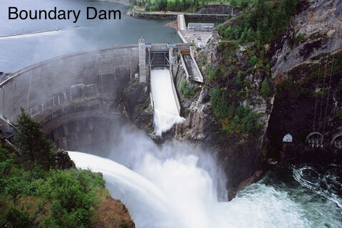
BOUNDARY DAM Just north of Metaline Falls, Washington, a powerful dam stands on the Pend Oreille River. At 340 feet tall, the concrete double-curvature arch of Boundary Dam cuts an imposing figure. Its output is also impressive. At any given moment, Boundary Dam can generate more than 1,100 megawatts of electricity. That's enough energy to power downtown Seattle. While most City Light customers will never visit Boundary Dam, they all benefit from this keystone piece of City Light infrastructure. Dedicated in 1967, Boundary Dam celebrated its 50th anniversary in 2017. The dam has had a significant impact on the region and will continue to provide electricity for City Light customers into the future. This exhibit explores the herculean undertaking of building the dam, the impact of the dam over the years and facts on the dam's power and size.
Boundary Dam at night, November 1967 Item 189915, Record Series 1204-01
Future Boundary Dam site, view from downstream, May 29, 1962 Item 182499, Record Series 1204-01
Boundary Dam spilling, Nov. 6, 1998 Item 149513, Record Series 0207-01 The Kalispel Tribe of Indians were the first reported people to call the area around today's Boundary Dam home. Ancestors of the modern Kalispel hunted, fished and dwelled in the region along the Pend Oreille River for more than 8,000 years. The region as we know it today began to take shape in the mid-1800s as pioneers, fur traders and prospectors began to settle in the area around present-day Metaline Falls, Metaline and Ione. Early on, entrepreneurs recognized the vast zinc and lead deposits of the region, and the Metaline Mining District would become one of the largest domestic producers of those metals for most of the 20th century. The potential of the Pend Oreille River to produce hydroelectricity was also recognized early on by entrepreneurs from across the United States and Canada. In 1914, renowned engineer Col. Hugh L. Cooper began surveying Z Canyon on the Pend Oreille River for a site suited to development of a large dam. Although his plan ultimately failed due to a lack of funding and an abundance of red tape, it was the first of many attempts to utilize the local landscape for hydroelectricity. The Z Canyon site was one of many being proposed by various utilities statewide in 1944.
Photo of Pend Oreille River at Z Canyon for Col. Hugh L. Cooper, 1916 Box 6, Record Series 1206-07
Pend Oreille River at Z Canyon, with Peewee Falls in background, Panorama, June 1933 Box 6, Record Series 1206-07
Completed and proposed dams in Washington, 1944 Seattle City Light Official Bulletin No. 55, Record Series 1201-11 City Light announced its plan to acquire the Boundary Dam site and construct a hydroelectric power plant Oct. 27, 1953. This led to an outcry from the local mining industry, which was concerned about potential damage to the mines in the area. Difficulties continued when the Pend Oreille County Public Utility District submitted an alternative application to construct three additional dams on the river. On July 10, 1961, City Light was finally issued a license by the Federal Power Commission, granting the utility permission to utilize a section of the Pend Oreille River and construct Boundary Dam.
Aerial showing Metaline Falls and the Pend Oreille River, August 29, 1962 Item 110713, Record Series 1204-01
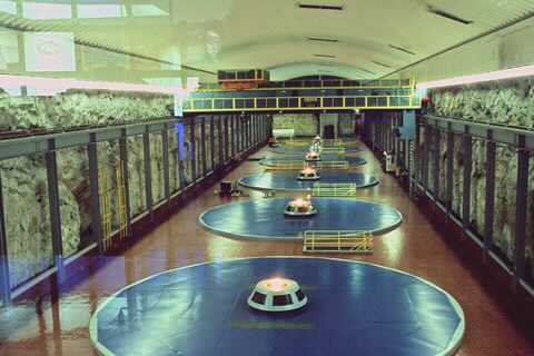
"To the People," August 3, 1957 City Light Boundary Dam Project Records, Box 6, Record Series 1206-07 Phase one of the project included building roads to the site. In phase two, the machine hall cavern was excavated, as well as the galleries, tunnels, power waterways, gate chambers and shaft, and elevator shaft. Construction in August 1963 included carving out 500,000 cubic yards of the limestone mountain to make way for, at the time, the world's largest underground powerhouse. The machine hall, which houses the turbine-generators that generate electricity, was excavated to be 15 stories below the ground. In phase three, the dam was constructed, including architectural and structural concrete, cranes, hoists, sluices and gates. During phase four the generators, turbines, main transformers, related auxiliary mechanical and electrical equipment and finishings were installed. A progress report from September 10, 1965 states, "Shipments of turbine parts are arriving regularly at the project site, while fabrication of generators continues at the manufacturer's plant. Virtually all major equipment items have been ordered. Arrangements to transport and store incoming materials have been completed."
Boundary turbine parts arriving at Pier 20, May 1, 1965 Item 189985, Record Series 1204-05
Worker assembles Unit 51 turbine Item 189240, Record Series 1204-01
Unit 52 generator shaft being reloaded on work trailer for trip to machine hall, October 3, 1966 Item 189689, Record Series 1204-05
The first bucket of concrete was poured on November 12, 1965 Item 183446, Record Series 1204-01 Over a million cubic yards of rock excavation was required to create the forebay from which Pend Oreille River water is admitted to plant turbines through the intake tunnels and penstocks. Another half-million cubic yards was excavated to create the machine hall. A cavern 477 feet long, 76 feet wide and 170 feet deep would contain six large turbine-generators; only four units were installed initially. Silent film shot between about 1965 and 1967 shows excavation and construction of the Boundary Project (Item 32, Record Series 1204-04, SMA). The dam itself was built to an astounding 340 feet tall. The eggshell-like double curve of the dam's thin arch achieves great strength with exceptionally low mass. The concrete ranges from 32 feet thick at the base to only 8 feet thick at the crest. The dam has two large spillgates at the top on either side and seven sluice gates are located 200 feet below the crest of the dam. The gates enable the reservoir to be lowered, if necessary, and have the ability to drain the lake within 24 hours. The reservoir that retains the water from the Pend Oreille River is 1,794 acres and 17.5 miles long.
Thin arch observed through access- gallery portal, September 22, 1967 Item 183457, Record Series 1201-04
Plan of Boundary Dam and Power Plant, 1967 Progress Report, February 28, 1967, Record Series 1201-11
Left spillway, August 23, 1967 Item 183455, Record Series 1204-01
Aerial view looking downstream, showing forebay, trashracks and dam, August 28, 1966 Item 183461, Record Series 1204-01 On September 1, 1967, Boundary Dam produced commercial electricity for the first time. Within months of its opening, the project's four turbine generators produced as much as 600 megawatts of power, enough energy to power approximately 600,000 households. At its dedication, Seattle Mayor J.D. (Dorm) Braman lauded the dam for its immense benefit for the citizens of Seattle and northeastern Washington. All told, 1,300 workers were a part of the dam's construction. Today, it is operated by more than 40 City Light employees. City Light has continued to improve the power production of Boundary Dam, adding to its benefits to both Seattle and Pend Oreille County. Currently, City Light provides 48 megawatts of electricity at cost to the Pend Oreille County Public Utility District, significantly reducing power costs for their customers.
Mayor J.D. Braman at Boundary Dam dedication, September 27, 1967 Item 189927, Record Series 1204-01
Boundary Project Power Station Control Room, October 9, 1967 Item 190076, Record Series 1204-01
Map of City Light Power System, 1967 Seattle City Light's Boundary Project, Record Series 1201-11
City Light billboard at 4th and Spokane, 1968 Item 78730, Series 1204-01 In 1986, Boundary's power output grew with the addition of two new turbine generators to the machine hall. Transformer bays, water passages and machine-hall space were provided when the dam was built so that two additional turbine-generator units could be installed in the plant without further blasting of the rock. The machine hall was designed with exposed natural rock in its walls. Along with other improvements throughout the years, the electrical capability has increased to 1,117.4 megawatts. In a short production about the Boundary Hydroelectric Project created by SCL in 2006, animation (courtesy Alweis Film "Last Place Settled") shows how the dam works and footage of the turbines (Item 5336, Record Series 1204-04, SMA). Currently, Boundary Dam generates up to 35 percent of Seattle’s energy needs. Spillways cut into the rock are oriented in such a way that full-capacity discharges from both will meet in mid-air to dissipate the falling-water energy that might otherwise erode canyon walls. The spillways have a combined capacity of 108,000 cubic feet per second.
Generating turbine, Boundary Dam, May 20, 1999 Item 126695, Record Series 0207-01
Boundary Dam machine hall, June 27, 2004 Item 151247, Record Series 1204-19
Aerial of Boundary Dam spilling, 1991 Item 130648, Record Series 0207-01 A portion of the film The Postman, directed by and starring Kevin Costner, was filmed on the front of the dam. For a period of time in 1997, the dam's face had a facade of a town, known as Bridge City in the film. Metaline Falls was used as a local location set for the movie. The production brought in over $11 million to the local area.
Filming of The Postman, 1997 Courtesy The Cutter Theatre, Metaline Falls, WA
Filming of The Postman, 1997 Courtesy The Cutter Theatre, Metaline Falls, WA
Filming of The Postman, 1997 Courtesy The Cutter Theatre, Metaline Falls, WA In 2013, City Light was issued a new license to operate Boundary through 2055. The new license includes a suite of measures that mitigate for the impacts of Boundary's operations on the surrounding environment. These measures address recreation, fish and aquatic, terrestrial, cultural, and wildlife resources, and benefit the environment and the communities in and around Boundary. As part of the recreation measures, a completely renovated Forebay Recreation Area, including a campground and boat launch, will reopen in 2018. Improvements to the boat launch at Metaline Waterfront Park will take place in 2019. New canyon viewpoints, a portage trail, and a hiking trail will follow in 2020. The Boundary Hydroelectric Project was formally listed on the National Register of Historic Places on May 1, 2018. The nomination cited the dam's importance in the power generation response to the increased growth of the region in the post-World War II era as well as its lasting impact on the history and development of Pend Oreille County and the communities of Metaline and Metaline Falls. The nomination also cited the dam's distinctive characteristics of its type and period of construction. Boundary is the second tallest arch dam in Washington and its underground powerhouse is one of the largest examples in the United States.
Night scene of Boundary Dam spilling, December 8, 1998 Item 126710, Record Series 0207-01
Boundary Dam, August 30, 2017 Courtesy Nathan MacDonald, Seattle City Light To see footage of Boundary Dam construction and more, see SMA’s YouTube channelexternal link. This exhibit was created with support and expertise from Seattle City Light and assistance from David Ross, San Jose State University intern.
ONE NIGHT I CAME BACK FROM CANADA AND STAYED THE NIGHT AT BOUNDARY DAM. AS I WAS HAVING DINNER, I NOTICED THE AURORA BOREALIS WAS BUILDING. I WENT AROUND TO EACH CAMPSITE AND TOLD THE CAMPERS OF THE AURORAS. NOT ONE PERSON GOT UP TO SEE THEM.THEIR LOSS. CAN YOU FIND THE BIG DIPPER IN THIS IMAGE?
GARDNER CAVES, CRAWFORD STATE PARK
THE HISTORY OF BOUNDARY DAM, METALINE FALLS, WASHINGTON
For an interesting read on its history and the Upper 15 miles of the Pend Oreille River, log onto the below url