WANLESS LAKE VIA TRAIL’S #656, #360, #912
EVENT TYPE: Day hiking, backpacking
DISTANCE: 18 miles RT
ELEVATION: 3500’
DIFFICULTY: Difficult
MAPS: Kootenai N.F., Noxon Rapids, Howard Lake, Goat Peak
GPS: 48°00’45” N 45°34’53” W
RANGER DISTRICT: Cabinet Ranger District 406.827.3533
LINCOLN COUNTY SHERIFF: CALL 911 FIRST or 406.293.4112
DISTANCE: 18 miles RT
ELEVATION: 3500’
DIFFICULTY: Difficult
MAPS: Kootenai N.F., Noxon Rapids, Howard Lake, Goat Peak
GPS: 48°00’45” N 45°34’53” W
RANGER DISTRICT: Cabinet Ranger District 406.827.3533
LINCOLN COUNTY SHERIFF: CALL 911 FIRST or 406.293.4112
DESCRIPTION:
SWAMP CREEK TRAIL #924,
I haven’t hiked Trail #924, but can offer some incite.
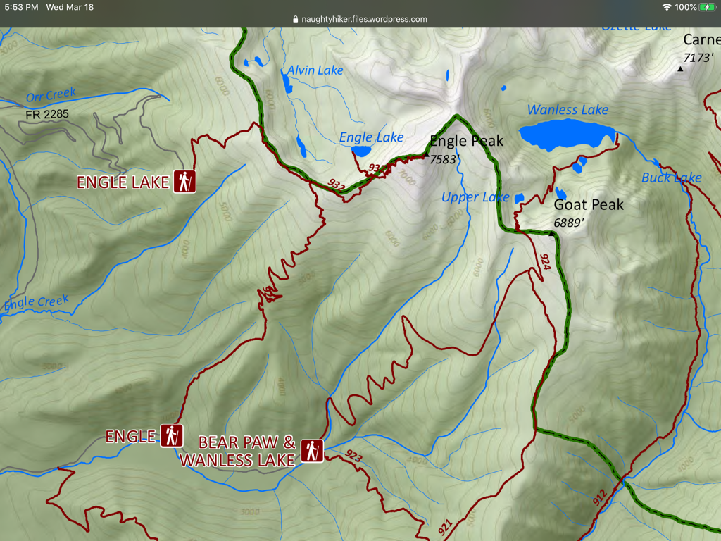
The trail skirts Swamp Creek to Buck Lake where it climbs to Wanless Lake and it’s exit waterfall. There are a total of 6 lakes on the upper slopes south of Wanless.
I haven’t hiked Trail #924, but can offer some incite.
The trail skirts Swamp Creek to Buck Lake where it climbs to Wanless Lake and it’s exit waterfall. There are a total of 6 lakes on the upper slopes south of Wanless.
TRAIL #921
EVENT TYPE: Long day hike, backpacking
DISTANCE: 26 miles RT
ELEVATION GAIN: 2500’
DIFFICULTY: Strenuous
MAPS: Kootenai N.F., Goat Peak topo
GPS: 47°55’02” N 115 57’00” W
RANGER DISTRICT: Cabinet Ranger District 406.827.3533
LINCOLN COUNTY SHERIFF: 911 or 406.293.4112
DISTANCE: 26 miles RT
ELEVATION GAIN: 2500’
DIFFICULTY: Strenuous
MAPS: Kootenai N.F., Goat Peak topo
GPS: 47°55’02” N 115 57’00” W
RANGER DISTRICT: Cabinet Ranger District 406.827.3533
LINCOLN COUNTY SHERIFF: 911 or 406.293.4112
DESCRIPTION:
The 13 mile trail takes more then 6 hours to complete.
From the trailhead, drop down to beneath the power lines to pick up the long trail to Wanless Lake.
At about 12 miles you will come to Buck Lake. Wanless Lake sits NW up in it’s cirque.
From the trailhead, drop down to beneath the power lines to pick up the long trail to Wanless Lake.
At about 12 miles you will come to Buck Lake. Wanless Lake sits NW up in it’s cirque.
OPTION #1:
Once at Buck Lake, you can access the Cabinet Divide Trail by turning east up Trail #912
DIRECTIONS:
On Hwy 200, drive 5 miles to near milepost 20, and turn east onto Swamp Creek Road for 2.5 miles. As this road comes to a bend to the south, make a sharp left (north), and drive 2 miles to the trailhead.
HAZARDS:
Long slow hike to Buck Lake.
DIRECTIONS:
MCKAY Creek Road #1022
Take Hwy 200, to 3 miles past the Noxon Bridge to the McKay Creek Road #1022. It’s turn off is opposite the Noxon Rapids Viewpoint. Turn left NE and drive 4 miles to the trailhead.
Take Hwy 200, to 3 miles past the Noxon Bridge to the McKay Creek Road #1022. It’s turn off is opposite the Noxon Rapids Viewpoint. Turn left NE and drive 4 miles to the trailhead.
HAZARDS:
NA
COOL THINGS CLOSE BY:
MCKAY Creek Road #1022
Take Hwy 200, to 3 miles past the Noxon Bridge to the McKay Creek Road #1022. It’s turn off is opposite the Noxon Rapids Viewpoint. Turn left NE and drive 4 miles to the trailhead.
Take Hwy 200, to 3 miles past the Noxon Bridge to the McKay Creek Road #1022. It’s turn off is opposite the Noxon Rapids Viewpoint. Turn left NE and drive 4 miles to the trailhead.
R & P:
Henry’s & Pizza Hut, in Libby, Clark Fork Pantry, Eicharts, Mr Sub & Jalapeños in Sandpoint
PLAN YOUR TRIP:
Click for Current NOAA Weather Conditions


