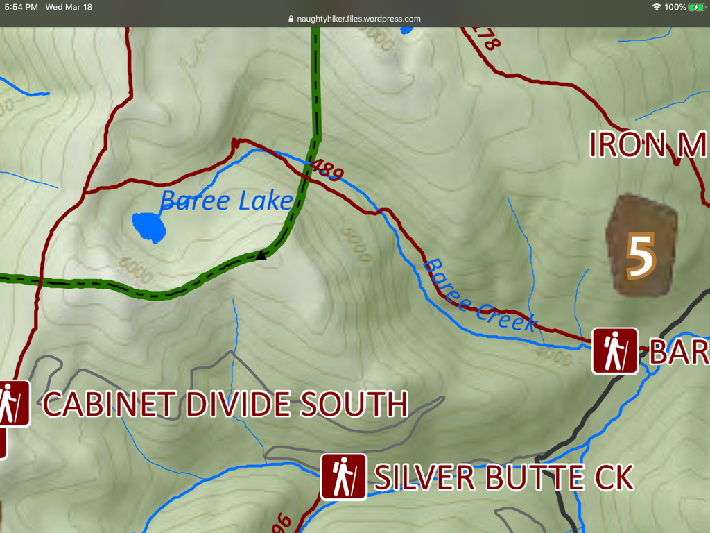
BAREE PEAK 6442’ & LAKE TRAIL #489
EVENT TYPE: Day hiking, backpacking
DISTANCE: 8 miles RT
ELEVATION GAIN: 2700 verts
DIFFICULTY: Difficult
MAPS: Kootenai N.F., Silver Butte Pass, Goat Peak topos
GPS: 47°57’41” N 115°32’23” W
RANGER DISTRICT: LIBBY RANGER DISTRICT: 406.293.7773
LINCOLN COUNTY, MT SHERIFF: 911 or 406.293.4112
DISTANCE: 8 miles RT
ELEVATION GAIN: 2700 verts
DIFFICULTY: Difficult
MAPS: Kootenai N.F., Silver Butte Pass, Goat Peak topos
GPS: 47°57’41” N 115°32’23” W
RANGER DISTRICT: LIBBY RANGER DISTRICT: 406.293.7773
LINCOLN COUNTY, MT SHERIFF: 911 or 406.293.4112
DESCRIPTION:
WE HAVE ADDED THE AREAS SHERIFF’S EMERGENCY PHONE NUMBERS FOR EACH TRIP WRITE UP UNDER THE RANGER DISTRICT INFO. IF AN EMERGENCY OCURRS, EVALUATE YOUR CIRCUMSTANCES AND CALL ONLY IF NEEDED.
On the southern edge of the Cabinet Mountain Wilderness, sits Baree Mountain 6050’. It’s grassy dome shaped has nice high meadows to enjoy. Once at the lake, look SE for an old miners cabin, which is deteriorating.
There is a primitive campsite on the lake’s SE shore.
On the southern edge of the Cabinet Mountain Wilderness, sits Baree Mountain 6050’. It’s grassy dome shaped has nice high meadows to enjoy. Once at the lake, look SE for an old miners cabin, which is deteriorating.
There is a primitive campsite on the lake’s SE shore.
OPTION #1:
The route from the lake to Baree Mountain is done by skirting the lake to the south, then up several rocky ledges SE to the summit. This route offers some great scrambling.
OPTION #2:
For a nice loop hike, try the below hike.
Trail #489 continues past the lake to the Cabinet Divide Trail #360. Once on 360, turn NNE to Trail #63, and turn SSE to a faint Trail out to Bear Lake. Then hike back to Trail #63 and turn left (East) past Trail #360 to Trail #531, to its trailhead. Once on F.R #148, turn right SE for a short distance to the Baree Lake trailhead.
Trail #489 continues past the lake to the Cabinet Divide Trail #360. Once on 360, turn NNE to Trail #63, and turn SSE to a faint Trail out to Bear Lake. Then hike back to Trail #63 and turn left (East) past Trail #360 to Trail #531, to its trailhead. Once on F.R #148, turn right SE for a short distance to the Baree Lake trailhead.
DIRECTIONS:
EAST TRAILHEAD
From Libby, head south on Hwy 2 towards G.N.P., for about 20 miles to Sedlak Park. Turn south on Silver Butte-Fisher River Road #148, then drive about 10 miles to the trailhead.
WEST TRAILHEAD
From the Vermillion River Road#154, look for milepost 7, and turn left up Silver Butte Road #148, for about 8 miles to the trailhead.
HAZARDS:
None of note to the lake, but caution should be used scrambling up to Baree Mountain.
COOL THINGS CLOSE BY:
Bear Lake, Geiger Lakes, Bramlet Lake, Carney Peak, Leigh Lake, Wanless Lakes, Cliff-St.- Paul L. -Chicago Peak-Rock Lake
R & P:
Henry’s & Pizza Hut, in Libby, Clark Fork Pantry & Squeeze Inn in Clark Fork. Eicharts, Mr Sub & Jalapeños in Sandpoint


