INLAND NW ROUTES |
|
|
THE CABINET MOUNTAIN WILDERNESS Below are in my opinion, the best of the best hikes shown on our website.
One of my criteria is hiking in places where there aren’t many, if any other people. To achieve this, we provide OPTIONS. OPTIONS are hikes that take skills and off trail navigation. They should only be done by knowledgeable and capable enthusiasts. Click on the associated url’s to see my write ups on each hike. If you have specific questions about an area here or on our website, please feel free to contact me. At the bottom of every page is my email envelope. But do remember, I am often out doing research or enjoying these wonderful places. Contact me 2-3 days ahead of your hike, or call the Ranger district 3 days before every hike for more info. The Cabinet Mountain Wilderness is so cool, it was one of the areas designated as Wilderness in The 1964 Wilderness Act. Think of it as a mini Glacier National Park, but without the hoarders of people. The drive up Hwy 56, between the CMW and the PSPW, os me of my favorite drives. Rock Lake https://www.inlandnwroutes.com/rock-lake-4958.html This easy to access lake offers views different from a lot of places in the CMW. Rock Lake sits at the base of two very steep mountain. The famed Ojibway Peak towers to the NE of Rock Lake camp site Leigh Lake. Don’t miss this hike, but take it serious. https://www.inlandnwroutes.com/leigh-lake.html There are a couple of lakes as nice as Leigh Lake in the Wilderness, but access is more difficult. Leigh Lake is 1.52 miles, but gains over 1100verts There are ice bergs in June, waterfalls galore, and 3,000 foot headwall below Snowshoe Peak. Granite Lake https://www.inlandnwroutes.com/granite-lake-4629.html Granite Lake sits below A Peak, and frames the lake in outstanding scenery. The hike is thru a thick forest, and you will have to cross Granite Creek once. Be aware…it is a big creek, so look for the safest place to crossing. Cliff Lake, Chicago Peak, St. Paul Peak https://www.inlandnwroutes.com/cliffst-p-rock-p.html BE AWARE…IF YOU DONT HAVE VERY HIGH CLEARANCE VEHICLE, YOU WONT MAKE IT TO THE TRAILHEAD But along this road are spectacular views of the east face of the Proposed Scotchman Peaks Wilderness. From the trailhead to the Wilderness boundary is only 30 minute walk. As you walk along side Chicago Peak to get to Cliff Lake, the big mountain in front of you is St. Paul Peak. Look for Mountain Goats when you get to the lake. Then you skirt around the south side of St Paul Peak, steadily climbing to the summit. The view is from the middle of the Wilderness, so every direction is breathtaking. St. Paul Lake https://www.inlandnwroutes.com/st-paul-lake.html If you are a remote waterfall “FREAK”, this hike is for you. The Forest you ascend thru is worth the effort. Watch for gnomes. The lake is small, but is dwarfed by St. Paul Peak to the SSW. South of the lake are at least a dozen waterfalls scattered over a large area. Don’t forget you tripod. And be very careful walking around the shoreline. An interesting fact of this lake, is that it has no outlet creek. Eventually, the creek surfaces and becomes the East Fork Bull River
0 Comments
We are very fortunate to live within 3-4 hours of some incredible hiking. Below are in my opinion, the best of the best hikes shown on our website. One of my criteria is hiking in places where there aren’t many, if any other people. To achieve this, we provide OPTIONS. OPTIONS are hikes that take skills and off trail navigation. They should only be done by knowledgeable and capable enthusiasts. Click on the associated url’s to see my write ups on each hike. If you have specific questions about an area here or on our website, please feel free to contact me. At the bottom of every page is my email envelope. But do remember, I am often out doing research or enjoying these wonderful places. Contact me 2-3 days ahead of your hike, or call the Ranger district 3 days before every hike for more info. EVERY FEW DAYS, I WILL ADD A DIFFERENT AREA WITHIN OUR REGION IDAHO
THE AMERICAN SELKIRKS (A.S.) This very unusual mountain range starts at Mica Peak, near Spokane, and stretches over 300 miles north into British Columbia. About 100 miles of the Selkirks are in Idaho. An important note about the Selkirk Granite….it is a gnarly rock that allows you to ascend steep slabs. So just don’t fall. WEST FORK LAKE, MOUNTAIN, RIDGE & TOWER https://www.inlandnwroutes.com/west-fork-lake-mountain-6416--lookout-tower-trail-347.html Really the hardest part of this hike is the drive. From Rathdrum it take 3+ hours. But the roads are pretty good. Once at the lake, head up to the ridge on the west side. From the abandon lookout tower, walk NW & N along the ridge for a very nice walk. There are two lakes to enjoy along this ridge. Once back at the tower, head SE to experience a beautiful ridge walk. TWO MOUTH LAKES & MYRTLE’S TURTLE https://www.inlandnwroutes.com/two-mouth-lakes-5785.html Lower Two Mouth Lake is the prettiest high country lake, and warm enough to swim in. To the ESE is Upper Two Mouth Lake. It isn’t as spectacular as lower lake. But next to it, is Myrtle’s Turtle. When you are walking the lower section of the trail, Myrtle’s Turtle is the gigantic granite dome you see from the trail. From the upper lake, it’s an easy walk to the top. Don’t miss going to the top. You will be amazed. HARRISON LAKE & PEAK https://www.inlandnwroutes.com/harrison-lake--peak-7292-trial--217.html Harrison Lake Trail is the furthest trail up the Pack River Road. The trail is easy to follow, but up high you switch from a dirt trail to walking up granite slabs. Once at the lake the views of the Selkirk Crest are to the south. Off to the north is Harrison Peak. It’s a little more challenging to summit, but a must visit. THE WIGWAMS. https://www.inlandnwroutes.com/the-wigwams-7033.html Do not miss this hike, high clearance vehicles are needed. The hike to the Wigs is on an easy trail to an old helipad and the Wigwams summit next door. Once at the helipad, walk east along a magnificent cliff edge. After about 1.2 miles, the views open up. Do not miss this view. The American Selkirks stretch out for over ten miles. From Harrison Peak on the north, to Chimney Rock and Mount Roothaan to the south. It looks like you are looking down a saw blade. This is my favorite backpack. BEEHIVE LAKE TO LITTLE HARRISON LAKE https://www.inlandnwroutes.com/little-harrison-lake-6271--peak-7292.html Beehive Lake is a moderate enjoyable hike. From Beehive to L.H.L. is strenuous, but doable. It is all off trail and requires some easy scrambling. L.H.L. is encased in granite. Making the shoreline spectacular. When at L.H.L. the Selkirks Crest fills the western view. SELKIRK CREST HIGH TRAVERSE https://www.inlandnwroutes.com/selkirk-crest-high-traverse.html This hike/scramble, takes you to three of the American Selkirks most beautiful alpine Lakes, along the Selkirk Crest, and to the summit of Peak 7171’. However, the trailheads are a little over a mile apart. Leave a car at Beehive Trailhead, or walk the mile+ up to Harrison Lake Trailhead. This is easily the best day hike in the A.S. CHIMNEY ROCK & MOUNT ROOTHAAN https://www.inlandnwroutes.com/mount-roothaan-7326-and-chimney-rock-7124-trail-256.html From the west, the Horton Ridge the trail is easy and relatively short. From the east, Pack River, the route is longer, with outstanding views. Chimney Rock is a technical climb, while Mount Roothaan is a pleasant rock hop to the summit. The views to the north, up the American Selkirks are worth the effort. FAULT LAKE https://www.inlandnwroutes.com/fault-lake-5980--hunt-peak-7058-trail-59.html The road is the hard part of this spectacular hike. The trail steadily climbs up to the basin that Fault Lake sits in. The first thing you notice when you see the lake, is the very large notch above the lake. This notch is actually a fault line. Hence the name Fault Lake. Hike up into the notch for great views of the A.S. From the south. COMING NEXT ARE BEST HIKES IN THE CABINET MOUNTAIN WILDERNESS PLAN AHEAD
As you are planning your outing, I strongly suggest calling the Ranger District of the area you want to recreate in, to learn of any last minute “ALERTS”. On all of our hike’s write ups, we have listed the managing agencies phone numbers, in the hike data section. The reason I suggest this, is because a few years ago, we drove for 2.4 hours, only to find that a bridge 200 feet from the cut off road, was being replaced. We ended up having to drive up Hwy 95 to Copeland, and south to the trailhead, adding 1 hour and about 30 miles. On our HOME PAGE, if you scroll down, you will find the managing agencies “ALERTS” url’s. Tap on the appropriate url to see the MANAGING AGENCIES “ALERTS” page. Please keep in mind, ALERTS notifications don’t appear instantly. That’s why I suggest calling the Ranger District a few days before, to make sure your outing happens as planned. As long as we are in the planning stage, under the below url, you will find 4 websites that will allow you to see and read any issues, like fires, direction of smoke plumes, winds, etc., in our region. https://www.airnow.gov/ www.windy.com https://www.weather.gov https://inciweb.nwcg.gov/ To learn about weather in all its wonders, check out this url. https://www.inlandnwroutes.com/weather-thunderstorms-and-lightning.html Chic David InlandNWRoutes.com Have any of you hiked into a lake or peak, only to feel your heels on fire?
There is a 100% treatment for blisters and related pain. And it’s not Mole Skins. However, I carry them for padding. You may have to order SPENCO 2nd Skin Burn Pads, online, but I can guarantee you, you will walk away without any pain from that mountain top, or Lake. SPENCO also makes 2nd Skin precut patches, but in all my years, the burn pads never once failed me. And pads may not cover the whole blister. Put the 2nd Skins in your 13 ESSENTIALS, and include athletic tape, alcohol wipes, and scissors. A few years ago, I led a hike to Gold Hill due west of Stevens Peak. When we got to the top, I noticed one of the girls was limping in pain. I had her lay on her stomach while I cleaned and treated her blisters, and applied the burn pads. She put her socks on, then the boots, and she was blown away when she walked with ZERO PAIN. These burn pads are medicated, causing a soothing feeling. Of course they can be use for any of a number of issues, like burns, making these burn pads ESSENTIAL. Your 13 ESSENTIALS should contain an adequate first aid kit. Stock it with those items that will work for you. But most importantly…if you use any items, make 100% sure you restock them. I had to use dental floss to close a friends puncture wound, about 200verts from the summit of Snowshoe Peak, in the Cabinet Mountain Wilderness. If you don’t learn anything from these BLOGS, learn that if you are prepared to succeed, your chances are much higher. When you arrive at the trailhead, ask your fellow hikers to let everyone know when hot spots or full blown blisters are bothering them. Explain that the sooner a person gets treated, the less pain they will have to endure. Thank You for being our readers. Chic David InlandNWRoutes.cm You’re probably thinking, why would anyone plan to fail?
I would bet all of us at one time or another, found ourselves in deep doo. Arriving at a detour, or forgetting a key piece of clothing, or after driving 2-3+ hours to get to a trailhead, that has a closed road, are some problems with planning an outing. However, having said this, I included in each hike’s write up…….. COOL PLACES CLOSE BY: If for some reason your plans don’t happen as planned, the hikes listed in this section, are close by and somewhat like your original selection. This BLOG will tell you what I’ve experienced over 6 decades of adventures. And hopefully you will not make the same mistakes. SKILLS Of all the things we carry with us, the most important thing to take alone, weighs absolutely nothing. KNOWLEDGE What you don’t know, or plan for, can ruin a great day in Nature. And the most important thing to learn is navigation and orienteering. Batteries die. Phones get lost or broken, No reception. Having a map and compass will work around the clock. But you need to know how to use a compass. And you need to refresh that knowledge every few years. PLD, RECCO & AIRFLARE I carry a power supply that I can use for charging my devises, if necessary. Personal Location Devise These items are the best choice if you are going way back in Nature. Most PLD require a subscription to activate and use it. There are those PLD that all you need to do, is replace the battery every 5 years. No subscription. But they are the most reliable. AirFlare https://www.inlandnwroutes.com/blog/airflare-rescue-app-for-your-phone Along with knowledge, an AirFlare App, can save you. This app when activated, send your GPS coordinates to the local authorities. All you have to do is stay put and wait for the rescue crews to get to you. An easy rescue on the NE ridge from Stevens Peak, took 5.5 hours to get the injured person out, and a helicopter did all the hard lifting. Two Bear Air Helicopter Service came over from Kalispell, Montana, to extract the injured person. The AirFlare app is for your smart phone, hence it weighs nothing. The good news is, it cost a mere $4.99 a year. There are more features, but the S.O.S. button calls for help. RECCO RECCO is a battery free reflection strip that bounces the RADAR beam, back to the helicopter, alerting them of your whereabouts. Modern technical clothing has the RECCO strip sewed into the item. You can order the strips online, to attach to your pack. All of our area ski resorts and the Spokane Count use RECCO and AirFlare WEATHER Because I’ve ended up drench more that once, I have become very aware of the weather, and how to read it. NOAA is the go to website to get the most up to date info that is more accurate than any other source. Log onto the below url to read about all aspects of weather, and to learn about NOAA’s HOURLY WEATHER FORECAST. This graph will tell you when it will rain, sun, be cold and much more. This ski season, I referred to this graph hundreds of times, to plan my ski days. If you don’t know when or if it will rain, how can you properly plan a successful outing? Please read the below url to help you plan and succeed, in your adventure. https://www.inlandnwroutes.com/weather-thunderstorms-and-lightning.html CREATING A GROUP AND PLAN I call my hiking partners and let them know about a hike. From there, we can build our group. Pick your hiking partners carefully. Make sure each person has their own equipment, 13 ESSENTIALS, map, and knowledge to do the trip. When you go into the mountains, YOU are solely responsible for YOURSELF. Each person must have their own 13 ESSENTIALS, and know how to use them. The reason I say that, is because if one person gets separated, and they don’t have food, headlight, water and ESSENTIALS, they could be in trouble. A couple of years ago, a father daughter team went to the Cabinet Mountain Wilderness to backcountry ski. The father fell with a broken cornice, and his daughter had to spend the night out, WITHOUT ANYTHING. Fortunately, all ended well, and they were united. But remember she had nothing to get her thru the night. On our website there are two section called RESOURCES & HINTS. I encourage you all to read both of these sections. The more you know, the better your chances are to succeed. Make sure each person has a their own supplies. It’s very important that each hiker has a first aid kit, and knows CPR/FIRST AID. Plan your trip with the other members. Being involved in the planning, give each member as sense of belonging and responsibility. PERSONAL RESPONSIBILITY As you prepare for the outing, it is your responsibility to have the proper equipment and knowledge to succeed. I have lists of all the things I need to take, on whatever type of outing I’m planning. Start accumulating your gear. Check off the item on your list. Add or remove things as needed. And of course, make sure you have a person at home that can call authorities, if you don’t make it home by a certain time. On all of our activity write ups, are the phone numbers of the Ranger District, and the local Sheriff’s office. But not call the sheriff if it’s absolutely necessary. USFS RANGER DISTRICT At least three days before your trip, call the Ranger District, and inquire about any road closures, fires, washouts, etc. In our trip write up for your chosen outing is the phone numbers for the Ranger Station, and the Sheriff, only if needed. They can be found in RESOURCES under MANAGING AGENCIES. ALSO, if you scroll down the HOME PAGE, you will find each area FOREST ALERTS, URL’s. These alerts tell you of closures, fires, etc. BE AWARE…. Going into an officially closed area, is a fine of up to 5,000$ and possibility of up to 6 months jail time. Do not take chances. Benjamin Franklin once said… "IF YOU FAIL TO PLAN, YOU ARE PLANNING TO FAIL." David and I wish that your day in Nature is a great success. Chic David InlandNWRoutes.com As Spring grows warm around our region, TICKS come out to play. Tuesday, March 26th I did a training hike just north of Kellogg. Up near the top I stopped for a bite to eat. And there it was. Heading up my pant leg was, 2024’s first tick. I watched it until it got to my knee, then flicked it off. THIS IS AN UPDATE….since 4.2.24 (today is the 6th)I have picked off four ticks and extracted one from my chest. PLEASE examine your self and your clothes carefully. You might even have a change of clothes and a plastic bag to put your hiking clothes into before you get in your car. David and I have created a whole section on ticks, why they climb onto us, what they do once they have snagged your pant legs, and how to deal with an imbedded tick. Ticks climb up animals legs, heading for the back of the deer, elk or other critter’s necks to imbed. Why you ask? A deer, elk or most other large animals can’t scratch the back of their necks, to dislodge the ticks. Elk are huge and majestic animals, but an infection of many ticks can kill a deer, moose, or elk, painfully. That’s why they move up your body to imbed. Ticks can be temporary stopped under belts, elastic of underwear, bra straps, pant leg zipper flaps, or any other restriction. Washing machines do not kill ticks. It is your responsibility to carefully examine yourself or others. Examine your hiking clothes, seams, folds, and any place a tick can hide, or is restricted. PREVENTION Ticks climb up low laying grasses or twigs, and wait for something furry to snag onto. If you wear light colored pant and shirts, they become easier for you, or your hiking partners to spot them, and flick them off of you. If you tuck your pant legs into your socks, they don’t have an avenue to get to your skin. Same goes for your waist. During your hike, keep a close eye out for them anywhere on your body, clothes, or hair.  WHAT TO DO IF YOU FIND AN IMBEDDED TICK
A tick takes about 24 to 36 hours to crawl up your body looking for a place to attach to you. In that period of time, have your self, spouse or others, examine every square inch of your skin, for ticks that can be the size of a pin head to about a quarter of an inch in diameter. They don’t lay flat on the skin necessarily but rather burry their heads, leaving their bodies sticking up. Check armpits and belly buttons. If a tick is found imbedded in your skin, follow the procedures listed in our WILDLIFE section. https://www.inlandnwroutes.com/wildlife1.html Basically, clean the area around the tick, with an alcohol wipe. Use a set of flat blade tweezers to gently but firmly extract the tick. The tweezers should come in from the side, and grasp the tick at your skins level. After ticks imbed in your skin, they have barbs and use a “glue” to anchor themselves. (So scratching won’t extract them, necessarily.) With the tweezers, keep them horizontal to your skin, and pull straight up. Because of how they attach to us, they are difficult to break loose of your skin. DO NOT squeeze to hard. It may cause them to vomit in your wound. DO NOT DISCARD A TICK THATS BEEN IMBEDDED. DO NOT THROW THEM AWAY! Once you get the tick out of your skin, examine it carefully. If the tick is missing any of its 8 legs, or mouth parts, YOU NEEED TO DEAL WITH IT IMMEDIATELY. Use alcohol wipes to sterilize the area. Then examine the wound for ANY, usually dark spots under your skin or in your wound. If you see a dark spot, use a fingernail to dig in the wound to get it cleaned out. If a tick part is left in your skin, it could infect the area, and cause greater issues. After all that, clean the area affected with alcohol wipes, and place a band aid over the wound. DO NOT DISCARD THE IMBEDDED TICK If by chance the affected area turns red, or proceeds to red target shaped circles, see your doctor IMMEDIATELY. The reason we want you to keep the extracted tick is simple. It may take days for your blood test to confirm a specific illness. But it may only take hours for medical personnel to confirm that the tick was infected. After extraction, I put them in a small jar and keep them in the freezer until I’m cleared of any infection. Date the jar, and discard after a year, just to be safe. TICKS ARE COOL LITTLE CRITTERS Did I just say they are “cool”? Yes, I did. Do you know a tick is actually an arachnid (spider). They have 8 legs. Did you know, you can not kill a tick with your bare hands? That is, until it’s engorged with blood. They are so well adapted to what they do, they are ballistic until engorged. If you find one on your clothes, put it on a finger and examine it as it walks around. IT WILL NOT BITE YOU. TICKS DO NOT BITE. PLEASE log onto the url above to read our thorough article on ticks and exactly how to safely extract them. There are illustrations on how to properly extract a tick. If you arm yourself with knowledge, the chances of getting infected are slim. While you are in the WILDLIFE section, read about bears, rattlesnakes, and Poison Ivy, and more. We are committed to keeping you up to date on all aspects of our website’s information. Thank You for using our website. If you have specific questions, please email me at……chicski@icloud.com Chic David InlandNWRoutes.com blog-51-2024-two-bear-air-rescue-info.htmlblog-51-2024-two-bear-air-rescue-info.html
BE SURE TO WATCH THIS VIDEO https://vimeo.com/921329656 Hi InlandNWRoutes Readers, Today I would like to tell you about a group of people from Montana that has rescued one of our own, at no cost. Two Bear Air video https://vimeo.com/921329656 TWO BEAR AIR RESCUE SERVICE TWO BEAR AIR flies out of the Kalispell area, all over Eastern Washington, all of Montana & Idaho and more. They are equipped with the latest helicopter technology and the most trained and extraction rescue personnel in the business. Early last year, a hiker was injured, and could not get out on their own or with the other hikers help. 911 was called, and within hours, a helicopter was hovering overhead. The injured hiker was hauled up to the helicopter thru the trees, and flown to Lookout Pass Ski Area, where there was an ambulance waiting. First the Shoshone County Sheriff’s office was called for help. They dispatched three rescue personnel to find us and evaluate the injuries. The SAR officer called TWO BEAR AIR and explained the circumstances. Within 1.5 hours, the helicopter was overhead, and the injured person was on the way to get medical help. Now let me explain something. When 911 is called, it take many hours to build a rescue team, get to the garage and trailer and snowmobiles, and get to a launch point for the rescue. If the terrain is rough, it take time to get to the victim on foot. In the above case, we were only 3 miles from Mullan, but it took over 5+ hours, before the injured party was extracted. During that time, the others on the hike need to attend to all the victims needs, making sure they don’t get cold or wet. Drink water if it’s not a hazard from the injury, treat for shock if needed, or stop any bleeding. If the victim is or goes unconscious, you need to know exactly what to do. First Aid & CPR may be needed. You and the others on the trip may need to administer CPR. David and I strongly encourage all of you to take a certified CPR and First Aid course. All hikers should know, what to do in an emergency. This scenario , although serious, was not a life threatening, and the victim is already back hiking. Below are several BLOGS that I have written, that relate to the above story. PLEASE, read all these url(s) to familiarize yourself with what is needed during a time of an emergency. They may save you or a hiking partner from undo stress and evacuation perils. Davis and my goal, is to inform our readers of what precautions that need to go into the planning phase, the actual hike, and any scenario that may arise. BLOG #27 CALL 911 ONLY IN AN EMERGENCY BLOG #9. AIRFLARE RESCUE APP FOR YOUR PHONE BLOG #13. THE IMPORTANCE OF CARRYING A PACK AND 13 ESSENTIALS BLOG #19 WHAT DOES A RESCUE LOOK LIKE? BLOG #23. MEDICAL INFORMATION CARD (MIC) BLOG #36. 13+ ESSENTIALS & MORE If you would like to contact me, David has placed an envelope link at the bottom of every page, or below. Or chicski@icloud.com THANK YOU, for reading our website and our BLOGS. Chic David https://www.inlandnwroutes.com A WAY TO SEE WHERE YOU ARE AT, IF UNCLEAR. In early March 2024, while skiing SOB at Silver Mt., I skied out of bounds because of the luscious fluff. (Powder) When I realized what I had done, I stopped and pulled out my phone. I accessed the app…Ski Tracker. This app is used by skiers, snowshoers, and more to track their day’s activities. I use it to record my ski day’s journey. One of the features is Apple Map. It shows you your days skiing stats.m What I did was start the app, ski hiked up a ways, and consulted the map. It showed me exactly where I was, and where the trail I missed was, in relation to me. This gave me the info I needed to get up to the ski trail in the shortest and easiest way. Because it was the last run of the day, and I was 444verts below the trail, I was very concerned. I texted my ski buddy to notify the Ski Patrol, and started my traverse up to the trail. When I got to the chair lift, I borrowed their radio, and let the Ski Patrol know I was out and okay. Ski Tracker Lite, is a free app that can do all I described above. If you download it, you can put it in a snowshoe mode, that will track you, and give you info on your day’s hike. The app shows you your distance walked, elevation gain or loss, length of time you were out, highest angle walked up and down, speed you were walking, and altitude. 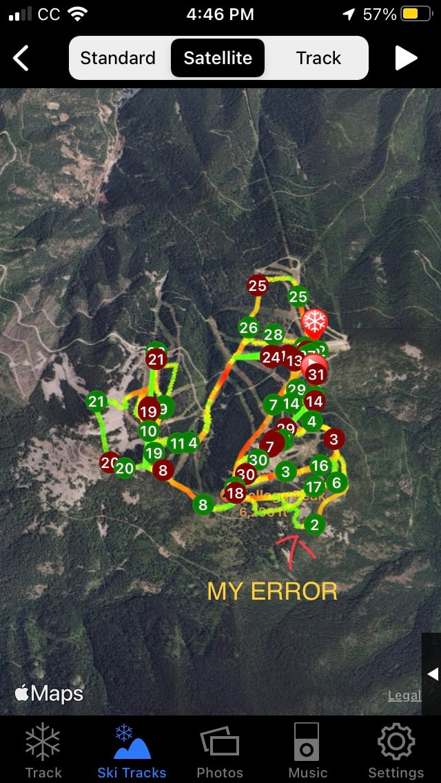 What this app did for me, was set my mind at ease, and show me that my error wasn’t terminal.
With lots of effort, I ski climbed, without skins, up to the trail, and back to the Mountain House. This app can be a life saver, and it’s free. Download….ski tracker lite, and know you have an avenue to see where you are at, when needed. AIRFLARE https://airflare.com Also, since I’m on the topic of getting unlost, there is another rescue app that I have downloaded to my phone. When there is an emergency, push the SOS button and it sends authorities your exact co-ordinance. If you move, push the SOS button to show your new location. NOW THE COOL PART The AirFlare app only costs $4.99 per YEAR. Most of the area ski hills utilize AirFlare. Check it out. But like any rescue, it takes hours to form the search party, and eventually get to you. Be patient and make yourself or your victim as comfortable as possible. And keep the victim warm and hydrated if it’s safe to do so. Have way toooo much fun, and be safe, and PLEASE be prepared. Thank You for reading our website. Chic David https://www.inlandnwroutes.com PRAIRE STARS SPRING 2024 WILDFLOWER SEASON
When skiing is slushy, or come to an end, I drive west into the Washington Channeled Scablands. March and April are wildflower months in The Scabs. Below are hikes in The Scabs that are sure to impress you. HOG CANYON https://www.inlandnwroutes.com/hog-canyon--falls.html ESCURE RANCH & TOWELL FALLS https://www.inlandnwroutes.com/escure-ranch.html NORTHRUP CANYON https://www.inlandnwroutes.com/northrup-canyon.html These two hikes can be done in one day STEAMBOAT ROCK https://www.inlandnwroutes.com/steamboat-rock.html FISHTRAP LAKE https://www.inlandnwroutes.com/fishtrap-lake.html JUNIPER DUNES WILDERNESS https://www.inlandnwroutes.com/juniper-dunes-wilderness.html SUN LAKES S.P. & DRY FALLS https://www.inlandnwroutes.com/sun-lakes-s-p-dry-falls-area.html Keep in mind, the wildflowers only last a short time in the Spring heat. By the end of April, might be too late for flowers. To make sure your trip will be sunny and nice, log onto…. WEATHER.GOV. Skip the “DETAILED FORECAST” words. They don’t tell the whole story. Then scroll down until you see the HOURLY WEATHER FORECAST. Click on the graph and study the data supplied. Basically it spells out the days hour by hour. I have notice over the years that the timing of a storm or sunshine is more accurate than the quantity of possible precipitation. It would be wise to call the area you wish to visit, to see when prime wildflowers are present. You can find the managing agencies phone numbers in each hikes write up. Enjoy the Spring by taking a walk, and seeing for yourself. Chic David InlandNWRoutes.com Winter time activities have taken a hit because of too little snow, rain, and/or unsafe conditions.
So as Winter melts away and Spring springs, keep vigilant on making sure you take adequate warm clothes, food and water. Until you have done a hike or two in which all the extra supplies aren’t needed, take gear as if it’s Winter. You can always stow it away, but if you don’t have it, the hike will be less fun. In the old days, I was teased because I always had 2 or 3 of everything, if someone needed an item, I had it. Plan ahead. I have lists for each of my needed for each type of activity. This way, I rarely forget stuff. And as Winter melts, treating your technical gear and ski gear, is important to do right away. Don’t let them stay unwashed until next ski season. Our RESOURCE SECTION and the BLOG below has a method that I’ve used for decades. Time-to-treat-your-outdoor-gear.html The Durable Water Repellent from https://www.gearaid.com, is a good choice to waterproof your gear. It’s a non-PFAS waterproof spray that works great. The key to washing technical jackets and pants is to use the proper laundry soap. I suggest Arm & Hammer powder soap. Check out the BLOG above for cleaning instructions. While you are at it, treat all your gear, skis, goggles, gloves, etc. so they can be ready for use as needed. Chic Burge David Crafton InlandNWRoutes.com |
AuthorWe would like to engage our users so we have started this blog so that we can interact with you. Please do not hesitate to comment on our posts if you have questions or things to add. BLOG ENTRY INDEX
Archives
April 2024
Categories |
 RSS Feed