INLAND NW ROUTES |
|
|
A WAY TO SEE WHERE YOU ARE AT, IF UNCLEAR. In early March 2024, while skiing SOB at Silver Mt., I skied out of bounds because of the luscious fluff. (Powder) When I realized what I had done, I stopped and pulled out my phone. I accessed the app…Ski Tracker. This app is used by skiers, snowshoers, and more to track their day’s activities. I use it to record my ski day’s journey. One of the features is Apple Map. It shows you your days skiing stats.m What I did was start the app, ski hiked up a ways, and consulted the map. It showed me exactly where I was, and where the trail I missed was, in relation to me. This gave me the info I needed to get up to the ski trail in the shortest and easiest way. Because it was the last run of the day, and I was 444verts below the trail, I was very concerned. I texted my ski buddy to notify the Ski Patrol, and started my traverse up to the trail. When I got to the chair lift, I borrowed their radio, and let the Ski Patrol know I was out and okay. Ski Tracker Lite, is a free app that can do all I described above. If you download it, you can put it in a snowshoe mode, that will track you, and give you info on your day’s hike. The app shows you your distance walked, elevation gain or loss, length of time you were out, highest angle walked up and down, speed you were walking, and altitude. 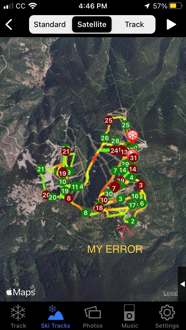 What this app did for me, was set my mind at ease, and show me that my error wasn’t terminal.
With lots of effort, I ski climbed, without skins, up to the trail, and back to the Mountain House. This app can be a life saver, and it’s free. Download….ski tracker lite, and know you have an avenue to see where you are at, when needed. AIRFLARE https://airflare.com Also, since I’m on the topic of getting unlost, there is another rescue app that I have downloaded to my phone. When there is an emergency, push the SOS button and it sends authorities your exact co-ordinance. If you move, push the SOS button to show your new location. NOW THE COOL PART The AirFlare app only costs $4.99 per YEAR. Most of the area ski hills utilize AirFlare. Check it out. But like any rescue, it takes hours to form the search party, and eventually get to you. Be patient and make yourself or your victim as comfortable as possible. And keep the victim warm and hydrated if it’s safe to do so. Have way toooo much fun, and be safe, and PLEASE be prepared. Thank You for reading our website. Chic David https://www.inlandnwroutes.com
0 Comments
PRAIRE STARS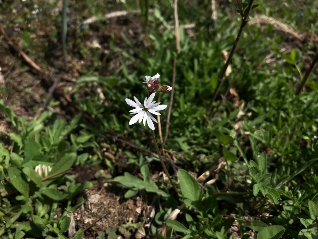 SPRING 2024 WILDFLOWER SEASON
When skiing is slushy, or come to an end, I drive west into the Washington Channeled Scablands. March and April are wildflower months in The Scabs. Below are hikes in The Scabs that are sure to impress you. HOG CANYON https://www.inlandnwroutes.com/hog-canyon--falls.html ESCURE RANCH & TOWELL FALLS https://www.inlandnwroutes.com/escure-ranch.html NORTHRUP CANYON https://www.inlandnwroutes.com/northrup-canyon.html These two hikes can be done in one day STEAMBOAT ROCK https://www.inlandnwroutes.com/steamboat-rock.html FISHTRAP LAKE https://www.inlandnwroutes.com/fishtrap-lake.html JUNIPER DUNES WILDERNESS https://www.inlandnwroutes.com/juniper-dunes-wilderness.html SUN LAKES S.P. & DRY FALLS https://www.inlandnwroutes.com/sun-lakes-s-p-dry-falls-area.html Keep in mind, the wildflowers only last a short time in the Spring heat. By the end of April, might be too late for flowers. To make sure your trip will be sunny and nice, log onto…. WEATHER.GOV. Skip the “DETAILED FORECAST” words. They don’t tell the whole story. Then scroll down until you see the HOURLY WEATHER FORECAST. Click on the graph and study the data supplied. Basically it spells out the days hour by hour. I have notice over the years that the timing of a storm or sunshine is more accurate than the quantity of possible precipitation. It would be wise to call the area you wish to visit, to see when prime wildflowers are present. You can find the managing agencies phone numbers in each hikes write up. Enjoy the Spring by taking a walk, and seeing for yourself. Chic David InlandNWRoutes.com Winter time activities have taken a hit because of too little snow, rain, and/or unsafe conditions.
So as Winter melts away and Spring springs, keep vigilant on making sure you take adequate warm clothes, food and water. Until you have done a hike or two in which all the extra supplies aren’t needed, take gear as if it’s Winter. You can always stow it away, but if you don’t have it, the hike will be less fun. In the old days, I was teased because I always had 2 or 3 of everything, if someone needed an item, I had it. Plan ahead. I have lists for each of my needed for each type of activity. This way, I rarely forget stuff. And as Winter melts, treating your technical gear and ski gear, is important to do right away. Don’t let them stay unwashed until next ski season. Our RESOURCE SECTION and the BLOG below has a method that I’ve used for decades. Time-to-treat-your-outdoor-gear.html The Durable Water Repellent from https://www.gearaid.com, is a good choice to waterproof your gear. It’s a non-PFAS waterproof spray that works great. The key to washing technical jackets and pants is to use the proper laundry soap. I suggest Arm & Hammer powder soap. Check out the BLOG above for cleaning instructions. While you are at it, treat all your gear, skis, goggles, gloves, etc. so they can be ready for use as needed. Chic Burge David Crafton InlandNWRoutes.com HISTORY ON INLANDNWROUTES.COM
As David and I were building and writing our website, I came across historical articles about the various areas and recreation locations. I have those histories in one of two places for you to familiarize yourself with the area you are recreating in. WHERE TO FIND HISTORY ARCTICLES TRIP WRITE UPS Some history I have placed at the bottom of the write ups. See the below url. https://www.inlandnwroutes.com/upper-and-lower-stevens-lake.html Scroll down to learn interesting facts about the areas we play in. DOUBLE CLICK SUBTITLES On most subtitles I have included a comprehensive history. All you have to do, is double click them in the search engine, and read about facts and interesting articles. https://www.inlandnwroutes.com/montana2.html Did you know, that in two counties in Montana, the population is an astounding .03 persons per square mile? New York City has 26,402 people per square mile, for instance. Yes, history can be boring. But when you learn about the Great Avalanche of 1903 at the Stevens Lakes Trailhead, history came alive. For those of you who have hiked to Stevens Lakes, have you wondered what the 8” pipe that crosses the trail several times is all about. I am working on an article that should be posted by May, that will tell you the story of the pipe. I am also, going to make a note on the individual write ups that will alert readers that a history is available. Thank You all for reading our website. Chic David InlandNWRoutes.com FOREST ROAD #634 CLOSURE WILL BE RESCINDED, 7.15.24.
This road services the following hikes: PYRAMID LAKES & BALL LAKES PYRAMID PEAK LONG MOUNTAIN LAKE PARKER PEAK FISHER PEAK RUSSELL MOUNTAIN & RIDGE SOUTH END LONG CANYON TROUT LAKE & BIG FISHER LAKE HOWEVER FOREST ROAD #423 REMAINS CLOSED UNTIL 7.15.2024. THIS ROAD SERVICES MYRTLE LAKE & PEAK IF YOU HAVE QUESTIONS ABOUT THE RESCINDED ROAD ORDER #634, OR THE CLOSURE OF FOREST ROAD #432, PLEASE FOLLOW THIS LINK... https://www.fs.usda.gov/alerts/ipnf/alerts-notices David and I are dedicated to bring you the most up to date information on forest closures, forest fires, and other info you need to know before you head out into Nature. THANK YOU, for using InlandNWRoutes.com Chic Burge David Crafton InlandNWRoutes.com EL NIÑO AND WINTER SPORTS As you all know, we are always at the mercy of the weather. Whether we have La Niño or El Niño, we just have to deal with what we are dealt. This chart shows the years and intensity of both. 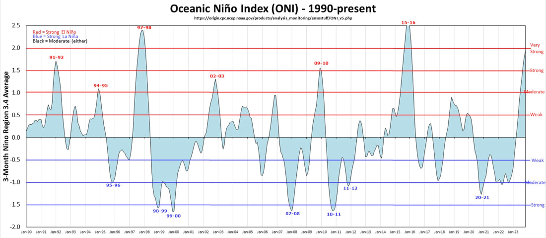 On average, we have about the same number of La Niños as we do El Niño.
But what you want to look at is the degree of intensity in both. Now with climate change, are we going to have more El Niño weather patterns? Of course we can’t predict the weather that far out, but we can learn to deal with weather, by adapting to the conditions, and doing the sports we love, in those conditions, if it’s safe. If you are as down as I am, about not being able to ski the fluff, go for a walk. Log onto NOAA.gov, and examine the illustrations and words to get an idea of where you might want to go. After you’ve looked and read the above, scroll down and click on the Hourly Weather Graph. Study this chart to get accurate times and amounts of precipitation, sky cover, wind speeds & direction, and temperatures thruout the day. After getting use to seeing this information, you can plan your day, down to the hour. We have a whole section on weather, that will show you what to expect in detail. https://www.inlandnwroutes.com/weather-thunderstorms-and-lightning.html Some places to hike, because... SKIING SUCKS RIGHT NOW Below are some suggestions of cool places to hike. Northrup Canyon & Steamboat Rock https://www.inlandnwroutes.com/northrup-canyon.html https://www.inlandnwroutes.com/steamboat-rock.html Escure Ranch, Rock Creek & Towell Falls https://www.inlandnwroutes.com/escure-ranch.html Navigation Trail, Lower to Upper Priest Lakes https://www.inlandnwroutes.com/navigation-trail-291.html Revett Lake and/or Blossom Lakes https://www.inlandnwroutes.com/revett-lake.html https://www.inlandnwroutes.com/blossom-lake.html Any of the following Spokane County Conservation Properties https://www.inlandnwroutes.com/spokane-county-conservation-futures.html Ross Creek Cedars https://www.inlandnwroutes.com/ross-creek-cedars1.html Don’t be down. But rather get up and go play. The advantages are numerous. No ticks Very low rattlesnake sightings No crowds None of the above, have avalanche dangers And most of all….new sights. If you have technical questions about any hike on our website, I encourage you to email me. My email is on the bottom of every page. Do keep in mind, I may be away doing “research”. (Hiking) Thank You for reading our website. Chic David InlandNWRoutes.com While doing some research for this website, I stumbled upon the NOAA OPERATIONAL HYDROLOGIC REMOTE SENSING CENTER. This NOAA website shows the snow depth of any area you are interested in skiing or hiking at. I haven’t done a lot of research on this website yet, but it promises to have more additional features to explore. For backcountry skiers, this website has a great deal of value. Now we can see the depth of snow at a given area, to make planning much easier and accurate. If you use this NOAA website this winter in planning a trip, please let me know what features you used and how accurate you found this information. I can be reached directly at chicski@icloud.com Thank You for reading our local website on places all over our region to play in Nature. Chic Burge David Crafton InlandNWRoutes.com INTERACTIVE SNOW INFORMATION https://www.nohrsc.noaa.gov/interactive/html/map.html?recenter=Zoom&ql=station&zoom=&loc=Mullan%2C+Idaho&var=ssm_depth&dy=2023&dm=12&dd=21&dh=3&snap=1&o11=1&o9=1&o13=1&lbl=m&o7=1&mode=pan&extents=us&min_x=-117.9&min_y=46.541666666662&max_x=-114.34166666667&max_y=48.541666666662&coord_x=-116.120833333335&coord_y=47.541666666662&zbox_n=&zbox_s=&zbox_e=&zbox_w=&metric=0&bgvar=dem&shdvar=shading&width=800&height=450&nw=800&nh=450&h_o=0&font=0&js=1&uc=0 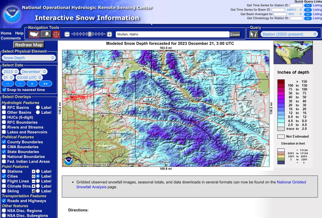 While doing some research for this website, I stumbled upon the NOAA OPERATIONAL HYDROLOGIC REMOTE SENSING CENTER. This NOAA website shows the snow depth of any area you are interested in skiing or hiking at. I haven’t done a lot of research on this website yet, but it promises to have more additional features to explore. For backcountry skiers, this website has a great deal of value. Now we can see the depth of snow at a given area, to make planning much easier and accurate. If you use this NOAA website this winter in planning a trip, please let me know what features you used and how accurate you found this information. I can be reached directly at chicski@icloud.com Thank You for reading our local website on places all over our region to play in Nature. Chic Burge David Crafton InlandNWRoutes.com INTERACTIVE SNOW INFORMATION https://www.nohrsc.noaa.gov/interactive/html/map.html?recenter=Zoom&ql=station&zoom=&loc=Mullan%2C+Idaho&var=ssm_depth&dy=2023&dm=12&dd=21&dh=3&snap=1&o11=1&o9=1&o13=1&lbl=m&o7=1&mode=pan&extents=us&min_x=-117.9&min_y=46.541666666662&max_x=-114.34166666667&max_y=48.541666666662&coord_x=-116.120833333335&coord_y=47.541666666662&zbox_n=&zbox_s=&zbox_e=&zbox_w=&metric=0&bgvar=dem&shdvar=shading&width=800&height=450&nw=800&nh=450&h_o=0&font=0&js=1&uc=0 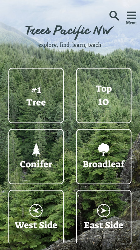 Have you ever been on a hike and spot a beautiful tree, and have no idea what kind of tree it is? Well, as the saying goes….”there’s an app for that”, kinda.
|
AuthorWe would like to engage our users so we have started this blog so that we can interact with you. Please do not hesitate to comment on our posts if you have questions or things to add. BLOG ENTRY INDEX
Archives
May 2024
Categories |
 RSS Feed